Rwenzori Mountains
📍 Uganda–DR Congo border
The 'Mountains of the Moon' — Africa's highest range not born of volcanism, carrying equatorial glaciers above a surreal bog world of giant heathers and lobelias.
What makes it marvelous
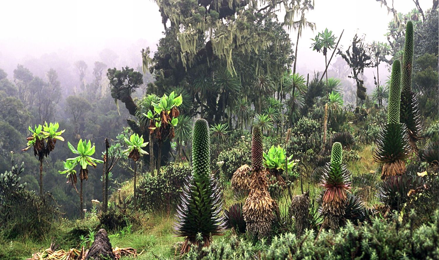
Unlike Kilimanjaro or Mount Kenya, the Rwenzori are not volcanoes: they were pushed up as a block of ancient rock along the Albertine Rift, making them Africa's highest non-volcanic range, topped by Margherita Peak at 5,109 metres. They are permanently wet, wrapped in cloud and rain almost year-round, and that endless moisture has produced one of the strangest ecosystems on the planet — an afro-alpine zone of giant groundsels and lobelias standing several metres tall, tree heathers draped in beards of moss, and deep, sucking bogs, all in a permanent green half-light. Above it all sit glaciers, remarkably, almost exactly on the equator, though they are retreating rapidly. Ancient geographers spoke of the 'Mountains of the Moon' as a source of the Nile, and the Rwenzori's meltwater does indeed feed it. It is a UNESCO World Heritage Site.
Why visit
Trekking the Rwenzori means days in a genuinely otherworldly landscape — mud, mist, and giant lobelias and groundsels that grow to the height of a house — climbing to equatorial glaciers on Africa's most mysterious and least-visited great range.
Still deciding?
Rwenzori Mountains comes up most often against one other place — each one weighs cost, effort, season and crowds side by side.
What to know before you go
🗓️ Best time
The drier windows (roughly December–February and June–August) offer the best chance of passable trails; the range is wet year-round and mud is guaranteed whenever you go.
🧭 Getting there & access
In western Uganda on the DR Congo border, reached via Kasese; the central circuit is a demanding 7–9 day guided trek with huts, and summiting Margherita requires glacier travel and technical gear.
Good to know
- Expect deep mud and rain whatever the season — waterproof everything.
- Allow 7–9 days for the central circuit; it is a serious, guided trek.
- Ascend slowly; the summit approaches exceed 4,500 m.
Plan your visit
Expedition🧭 Getting there
From Kasese, western Uganda
- Fly Entebbe → Kasese by light aircraft, or drive from Kampala — roughly 6h–7h by road
- Transfer Kasese → the Nyakalengija or Kilembe trailhead — about 30–60 minutes
- Trek the Central Circuit or Kilembe route to Margherita and back — roughly 7–9 days
- Total travel
- A full day to reach the trailhead from Entebbe
- Time at site
- A week or more on the mountain
- Access
- The Rwenzori is a national park and every trek runs through a licensed operator with park guides and porters — you do not walk it independently. Park fees and trekking permits are set by the Uganda Wildlife Authority and change, so confirm the current cost and the booking process with them or your operator rather than a fixed figure. Reaching Margherita Peak, the highest point, means crossing a glacier with rope and crampons and needs mountaineering experience; the lower circuit to the huts and lakes does not. The glaciers here are shrinking fast, and the route on the ice changes.
🎒 What to bring & consider
- A booked, guided trek — the park requires it, and the bog, the routefinding and the glacier make going alone a non-starter
- Full waterproofs and gaiters, because this is one of the wettest mountain ranges anywhere and long stretches are ankle-to-knee-deep bog
- A cold-rated sleeping bag and proper layers for freezing nights at the high huts, despite sitting almost on the equator
- Glacier equipment and the experience to use it if you are going for Margherita — crampons, rope and ice axe, not improvised
- Time built in for altitude, since the summit is over 5,000m and the ascent profile is genuinely demanding
👁️ What to expect
- Crowds
- Very few. This is a fraction as busy as Kilimanjaro and you may share the mountain with almost no one.
- Conditions
- Wet, muddy, cold and steep, through surreal giant-lobelia moorland to snow and ice up top.
- Facilities
- A chain of basic trekking huts on the main routes. Everything else is carried by your porters.
- The view
- The glaciated summits of Mount Stanley above the strange world of giant groundsel and lobelia, on one of the rare clear windows. The clouds part briefly and unpredictably, so patience does more than planning.
Times and requirements are approximate and change with season, weather, and local rules — confirm permits, fares, and schedules with operators before you travel.
Natural riches of the area
- Africa's highest non-volcanic range (Margherita, 5,109 m)
- Equatorial glaciers, now retreating rapidly
- A surreal afro-alpine zone of giant lobelias and groundsels
- Meltwater feeding the Nile — the ancient 'Mountains of the Moon'
Local food
- Matoke
- Steamed green plantain, the staple across Uganda.
- Groundnut stew
- Rich peanut-based sauces served with millet or posho.
- Highland produce
- Vegetables, fruit, and coffee from the fertile Rwenzori foothills.
The Rwenzori are Africa’s strangest great mountains. Unlike Kilimanjaro or Mount Kenya, they are not volcanoes at all — they were shoved up as a block of ancient rock along the Albertine Rift, making them the continent’s highest non-volcanic range, crowned by Margherita Peak at 5,109 metres. And they are permanently soaked, wrapped in cloud and rain almost the whole year round.
That endless moisture has grown one of the most surreal ecosystems on Earth. Above the forest lies an afro-alpine world of giant groundsels and lobelias several metres tall, tree heathers hung with beards of moss, and deep, sucking bogs, all in a permanent green half-light. Higher still sit glaciers, almost exactly on the equator, retreating year by year. Ancient geographers spoke of the ‘Mountains of the Moon’ feeding the Nile — and Rwenzori meltwater truly does. Wet, muddy, and little visited, this UNESCO World Heritage range rewards those willing to suffer for it.
Rwenzori Mountains: common questions
How do you get to Rwenzori Mountains?
From Kasese, western Uganda: Fly Entebbe → Kasese by light aircraft, or drive from Kampala — roughly 6h–7h by road; Transfer Kasese → the Nyakalengija or Kilembe trailhead — about 30–60 minutes; Trek the Central Circuit or Kilembe route to Margherita and back — roughly 7–9 days. Total travel time: A full day to reach the trailhead from Entebbe.
When is the best time to visit Rwenzori Mountains?
The drier windows (roughly December–February and June–August) offer the best chance of passable trails; the range is wet year-round and mud is guaranteed whenever you go.
How long should you spend at Rwenzori Mountains?
A week or more on the mountain. Total travel time: A full day to reach the trailhead from Entebbe.
What should you bring to Rwenzori Mountains?
A booked, guided trek — the park requires it, and the bog, the routefinding and the glacier make going alone a non-starter Full waterproofs and gaiters, because this is one of the wettest mountain ranges anywhere and long stretches are ankle-to-knee-deep bog A cold-rated sleeping bag and proper layers for freezing nights at the high huts, despite sitting almost on the equator Glacier equipment and the experience to use it if you are going for Margherita — crampons, rope and ice axe, not improvised Time built in for altitude, since the summit is over 5,000m and the ascent profile is genuinely demanding
Do you need a permit or guide for Rwenzori Mountains?
The Rwenzori is a national park and every trek runs through a licensed operator with park guides and porters — you do not walk it independently. Park fees and trekking permits are set by the Uganda Wildlife Authority and change, so confirm the current cost and the booking process with them or your operator rather than a fixed figure. Reaching Margherita Peak, the highest point, means crossing a glacier with rope and crampons and needs mountaineering experience; the lower circuit to the huts and lakes does not. The glaciers here are shrinking fast, and the route on the ice changes.
Is Rwenzori Mountains crowded, and what are conditions like?
Very few. This is a fraction as busy as Kilimanjaro and you may share the mountain with almost no one. Wet, muddy, cold and steep, through surreal giant-lobelia moorland to snow and ice up top. Facilities: A chain of basic trekking huts on the main routes. Everything else is carried by your porters.
Added Updated
More wonders to explore