Lake Assal
📍 Afar Triangle, western Djibouti
The lowest point on land in Africa — a lake 155 metres below sea level with no outlet, so saline that the salt has crystallised into a plain sixty metres deep along its western shore.
What makes it marvelous
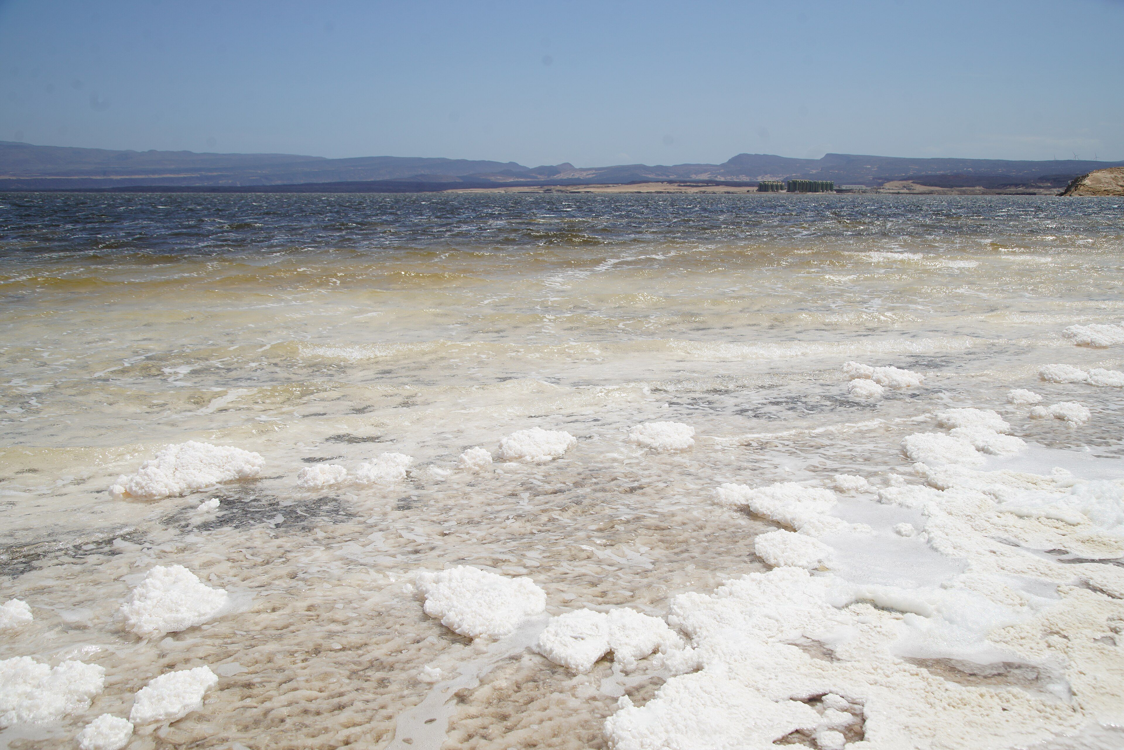
Lake Assal sits in a closed depression at the northern end of the Great Rift Valley, in the Afar Triangle where three tectonic plates are pulling apart. Its surface lies 155 metres below sea level, which makes it the lowest point on land anywhere in Africa. Seawater seeps in underground from the Gulf of Tadjoura a few kilometres east; nothing flows out. In a place where summer temperatures reach 52 °C, everything that arrives evaporates and leaves its salt behind, so the water has reached roughly ten times the salinity of the ocean — among the most saline bodies of water on Earth. The lake is oval, about 19 kilometres by 6.5, and divides into two halves: a brine body of 54 square kilometres reaching 40 metres deep, and beside it a blinding white crystallised salt plain of 68 square kilometres that extends more than 60 metres down, holding an estimated 300 million tonnes of salt.
Why visit
The colour contrast is extraordinary and entirely natural: black basalt hills, a white salt pan, and turquoise brine, with the Ardoukoba volcano nearby and the rift itself visible in the landscape. Salt caravans have been coming here for centuries to carry Assal salt up into the Ethiopian highlands, and the tracks are still in use.
What to know before you go
🗓️ Best time
November to February is the only comfortable window. Even winter daytime temperatures reach around 34 °C, and from May to September they can hit 52 °C, which makes any time on the salt genuinely dangerous.
🧭 Getting there & access
About 120 km west of Djibouti city, at the western end of the Gulf of Tadjoura, on a paved road built to serve the salt works. It is a straightforward half-day drive with a guide or a hired vehicle; there is no public transport worth relying on and no facilities at the lake.
Good to know
- Go in winter and go early. Heat here is the actual hazard, not the terrain.
- The salt crust is sharp and the brine will destroy leather — wear shoes you can rinse and discard.
- Do not get brine in your eyes; at this concentration it burns.
- Carry far more water than you expect to need. There is none on site, and none on the road.
Plan your visit
Easy🧭 Getting there
From Djibouti City (JIB), Djibouti
- Fly into Djibouti city
- Drive west along the Gulf of Tadjoura, roughly 120 km on paved road
- Descend into the closed depression to the lake shore
- Continue to the Ardoukoba volcano and Ghoubbet-el-Kharab if you have time
- Total travel
- About 2 hours from Djibouti city
- Time at site
- Half a day
- Access
- There is no entry gate, ticket or ranger presence — the site is open, and the road is paved because it serves the salt concessions rather than visitors. Most people come with a driver or on an organised half-day trip. There is no shade, no water and no shelter anywhere on site.
🎒 What to bring & consider
- Several litres of water per person; nothing is available anywhere on the route
- Sun protection and eye protection — glare off the salt is severe
- Shoes and clothes you are prepared to write off
- A vehicle with working air conditioning and a full tank
- Winter dates; this is not a summer destination in any sense
👁️ What to expect
- Crowds
- Light. A handful of vehicles at a time, mostly half-day trips from the capital.
- Conditions
- Extremely hot, dry, bright and exposed. Flat walking on sharp salt crust.
- Facilities
- None. Salt workings at the southeastern end; a few informal stalls selling salt crystals.
- The view
- The white salt plain running into turquoise brine with the dark basalt hills behind, in the first hours of light.
Times and requirements are approximate and change with season, weather, and local rules — confirm permits, fares, and schedules with operators before you travel.
Natural riches of the area
- The lowest point on land in Africa, 155 m below sea level
- Brine roughly ten times the salinity of seawater, with no outflow at all
- A crystallised salt plain of 68 km², over 60 m thick
- A brine body of 54 km², up to 40 m deep
- The Afar Triangle rift landscape and the Ardoukoba volcano alongside
Local food
- Skoudehkaris
- Rice cooked with lamb, cardamom and tomato — Djibouti's national dish.
- Lahoh
- A spongy fermented flatbread, eaten at breakfast with honey or stew.
- Fah-fah
- A spiced goat soup with vegetables and chilli.
- Red Sea fish
- Grilled whole in a clay oven, a Djibouti city speciality.
Djibouti is small and mostly hot rock, and in the middle of it is a hole in the ground with a lake at the bottom. Lake Assal lies 155 metres below sea level — the lowest point on land anywhere in Africa — in a closed depression at the northern end of the Great Rift Valley, in the Afar Triangle where the Arabian, Nubian and Somali plates are pulling away from one another.
The mechanism is simple and merciless. Seawater seeps in underground from the Gulf of Tadjoura, a few kilometres east. Nothing flows out. Summer temperatures reach 52 °C. Everything that arrives evaporates, and everything the water was carrying stays. The result is brine at roughly ten times the salinity of the ocean, which puts Assal among the most saline bodies of water on the planet.
What that produces is visually unlike anywhere else. The lake divides in two: a body of turquoise brine covering 54 square kilometres and reaching 40 metres deep, and beside it a crystallised salt plain of 68 square kilometres — white, blinding, and more than 60 metres thick, holding something like 300 million tonnes of salt. The hills around it are black basalt. There is very little in between.
People have been taking salt off it for a long time. Afar caravans carried Assal salt up into the Ethiopian highlands and traded it there, and those routes are old enough to have shaped the region’s commerce. Industrial extraction resumed in the 1990s under concessions at the southeastern end, and a paved road now runs the 120 kilometres from Djibouti city — built for the salt, and incidentally making one of the strangest landscapes in Africa a two-hour drive from an international airport.
Lake Assal: common questions
How do you get to Lake Assal?
From Djibouti City (JIB), Djibouti: Fly into Djibouti city; Drive west along the Gulf of Tadjoura, roughly 120 km on paved road; Descend into the closed depression to the lake shore; Continue to the Ardoukoba volcano and Ghoubbet-el-Kharab if you have time. Total travel time: About 2 hours from Djibouti city.
When is the best time to visit Lake Assal?
November to February is the only comfortable window. Even winter daytime temperatures reach around 34 °C, and from May to September they can hit 52 °C, which makes any time on the salt genuinely dangerous.
How long should you spend at Lake Assal?
Half a day. Total travel time: About 2 hours from Djibouti city.
What should you bring to Lake Assal?
Several litres of water per person; nothing is available anywhere on the route Sun protection and eye protection — glare off the salt is severe Shoes and clothes you are prepared to write off A vehicle with working air conditioning and a full tank Winter dates; this is not a summer destination in any sense
Do you need a permit or guide for Lake Assal?
There is no entry gate, ticket or ranger presence — the site is open, and the road is paved because it serves the salt concessions rather than visitors. Most people come with a driver or on an organised half-day trip. There is no shade, no water and no shelter anywhere on site.
Is Lake Assal crowded, and what are conditions like?
Light. A handful of vehicles at a time, mostly half-day trips from the capital. Extremely hot, dry, bright and exposed. Flat walking on sharp salt crust. Facilities: None. Salt workings at the southeastern end; a few informal stalls selling salt crystals.
Added
More wonders to explore