Laguna Colorada
📍 Eduardo Avaroa Andean Fauna National Reserve, Sur Lípez, Potosí Department, southwestern Bolivia
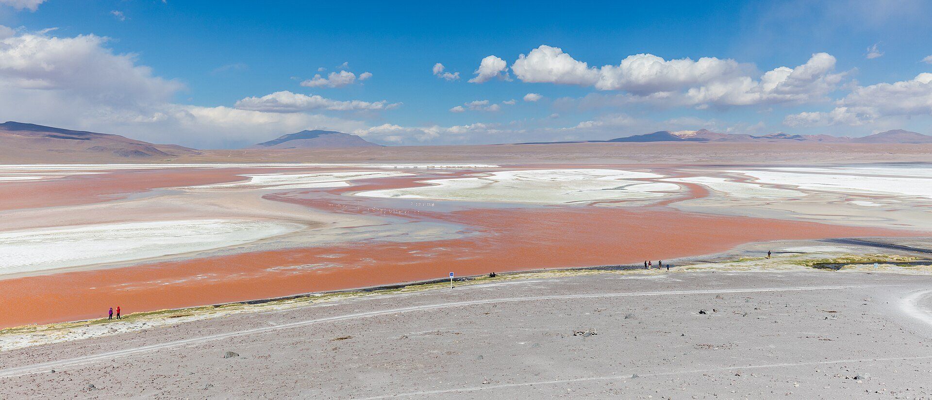
A shallow salt lake on the Bolivian Altiplano at 4,278 m whose water runs brick-red with algae and sediment, streaked with white borax islands and dotted with thousands of flamingos.
What makes it marvelous
Laguna Colorada covers about 60 km² but is extraordinarily shallow — on average about 35 cm deep and no more than 1.5 m. Its colour comes from red sediments and pigmented, salt-tolerant algae, chiefly Dunaliella salina, and shifts through shades of red and orange with the light and temperature, while islands of white borax stand out against the water. The lake is one of the most important breeding sites for James's flamingo, the most numerous species here, alongside Andean and Chilean flamingos. Listed as a Ramsar wetland in 1990, it now lies within the much larger Los Lípez Ramsar site, which holds about half of the world's James's flamingos.
Why visit
There is nothing else like it: a blood-red lake under a volcanic skyline at well over 4,000 m, with flamingos feeding across its shallows.
What to know before you go
🗓️ Best time
Tours run all year. November to January brings the warmest days, with highs around 20 °C; May to July is the coldest stretch. Nights fall below freezing in every season.
🧭 Getting there & access
Almost all visitors arrive on a multi-day 4x4 tour from Uyuni — Laguna Colorada is usually reached on the second day of the classic three-day route — or on the same circuit in reverse from San Pedro de Atacama in Chile. Uyuni has flights from La Paz and Cochabamba.
Good to know
- Spend a night or two acclimatising in Uyuni (about 3,700 m) before the tour, and learn the signs of altitude sickness.
- Carry about two extra litres of water a day and a warm sleeping layer — lodges near the lake sit at around 4,200 m.
- An entry ticket for the Eduardo Avaroa reserve is required; tour operators usually arrange it, but check what your tour price includes.
Plan your visit
Moderate🧭 Getting there
From Uyuni (UYU), by air from La Paz or Cochabamba
- Fly into Uyuni from La Paz or Cochabamba
- Join a multi-day 4x4 tour of the Salar de Uyuni and the Lípez
- Reach Laguna Colorada, usually on day two
- Total travel
- A 3-day tour from Uyuni (or from San Pedro de Atacama)
- Time at site
- An hour or two at the viewpoints, often with an overnight stay nearby
- Access
- There is no public transport — visits are by 4x4 tour on unpaved high-altitude tracks that climb to about 5,000 m. A reserve entry ticket is required.
🎒 What to bring & consider
- Time to acclimatise to altitude first
- Very warm layers, a hat and gloves — nights are below freezing
- Sunscreen and sunglasses for the intense high-altitude sun
- Extra water and snacks
👁️ What to expect
- Crowds
- Tour jeeps arrive in waves, but the lake shore is large and the landscape vast.
- Conditions
- Thin air, strong wind and big temperature swings; basic lodges at around 4,200 m.
- Facilities
- Simple shared lodges near the lake; little else for many kilometres.
- The view
- The red lake from the viewpoint above the shore, with white borax and flamingos in the shallows.
Times and requirements are approximate and change with season, weather, and local rules — confirm permits, fares, and schedules with operators before you travel.
Natural riches of the area
- Red water coloured by algae (Dunaliella salina) and sediment
- White borax islands
- A key breeding ground for James's, Andean and Chilean flamingos
- High Andean volcanic landscape of the Lípez
Local food
- Charque
- Dried llama meat, a traditional Altiplano staple.
- Quinoa soup
- Sopa de quinua, a warming bowl served across the high plateau.
High in the southwest corner of Bolivia, more than 4,200 metres above the sea, lies a lake the colour of brick. Laguna Colorada spreads across about 60 square kilometres of the Altiplano, yet it is astonishingly shallow — on average only about 35 centimetres deep.
Its colour is biological. Red sediments and salt-loving algae, above all Dunaliella salina, tint the water in shades of red, rust and orange that shift with the light and the temperature through the day. Islands and shores of white borax break up the colour, and behind the lake rise the bare volcanic peaks of the Lípez.
The algae also feed the flamingos. Laguna Colorada is one of the most important breeding grounds for James’s flamingo, the most common of the three species here, alongside Andean and Chilean flamingos. The lake was listed as a Ramsar wetland in 1990 and today sits inside the far larger Los Lípez Ramsar site, home to about half of the world’s James’s flamingos.
Getting here is part of the experience: almost everyone comes on a multi-day 4x4 tour from Uyuni, crossing the salt flat and a string of high lagoons. Acclimatise before you go, pack for freezing nights, and expect the thin air to make every step feel harder.
Laguna Colorada: common questions
How do you get to Laguna Colorada?
From Uyuni (UYU), by air from La Paz or Cochabamba: Fly into Uyuni from La Paz or Cochabamba; Join a multi-day 4x4 tour of the Salar de Uyuni and the Lípez; Reach Laguna Colorada, usually on day two. Total travel time: A 3-day tour from Uyuni (or from San Pedro de Atacama).
When is the best time to visit Laguna Colorada?
Tours run all year. November to January brings the warmest days, with highs around 20 °C; May to July is the coldest stretch. Nights fall below freezing in every season.
How long should you spend at Laguna Colorada?
An hour or two at the viewpoints, often with an overnight stay nearby. Total travel time: A 3-day tour from Uyuni (or from San Pedro de Atacama).
What should you bring to Laguna Colorada?
Time to acclimatise to altitude first Very warm layers, a hat and gloves — nights are below freezing Sunscreen and sunglasses for the intense high-altitude sun Extra water and snacks
Do you need a permit or guide for Laguna Colorada?
There is no public transport — visits are by 4x4 tour on unpaved high-altitude tracks that climb to about 5,000 m. A reserve entry ticket is required.
Is Laguna Colorada crowded, and what are conditions like?
Tour jeeps arrive in waves, but the lake shore is large and the landscape vast. Thin air, strong wind and big temperature swings; basic lodges at around 4,200 m. Facilities: Simple shared lodges near the lake; little else for many kilometres.
Added
More wonders to explore