Fish River Canyon
📍 ǁKaras, southern Namibia
Africa's largest canyon — a 160-kilometre gash up to 550 metres deep and 27 kilometres wide, where a river winds in vast loops through some of the oldest rock on the continent.
What makes it marvelous
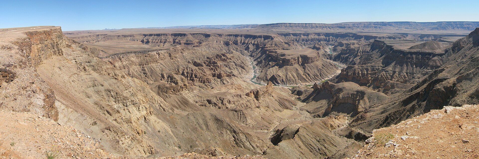
Fish River Canyon is the greatest canyon in Africa and among the largest anywhere: roughly 160 kilometres long, up to 27 kilometres wide, and plunging as much as 550 metres to the river below. Its formation was a two-stage affair — first a great fracture in the Earth's crust opened a rift, then the Fish River spent millions of years deepening and widening it, cutting through rocks that are among the most ancient on the continent, some well over a billion years old. The river now snakes along the floor in enormous meanders, reduced to a chain of pools for much of the year in this parched desert country. The canyon's multi-day hiking trail is one of Africa's toughest and most celebrated wilderness treks, and the sheer scale of the view from the rim, especially at sunrise or sunset, is staggering.
Why visit
Standing on the rim as the low sun rakes across a canyon so vast it swallows the horizon — or committing to the demanding multi-day trek along its floor — is one of southern Africa's great landscape experiences.
Still deciding?
Fish River Canyon comes up most often against these — each one weighs cost, effort, season and crowds side by side.
What to know before you go
🗓️ Best time
The cooler months (roughly May–September); the multi-day hiking trail is open only in this window, as summer temperatures in the canyon become dangerously extreme.
🧭 Getting there & access
In southern Namibia, reached by gravel road from Keetmanshoop or the Ai-Ais resort; rim viewpoints are drive-up, while the canyon-floor trail requires a permit, a group, and a medical certificate.
Good to know
- Come May–September; summer heat in the canyon is genuinely dangerous.
- Catch sunrise or sunset at the main viewpoint for the best light and depth.
- The floor trek is strenuous and permit-only — book and prepare well ahead.
Plan your visit
Strenuous🧭 Getting there
From Keetmanshoop, Namibia
- Drive Windhoek → Keetmanshoop — roughly 5h on tar
- Drive Keetmanshoop → Hobas, the northern viewpoint and hike registration — about 1h30–2h
- Continue to the main viewpoints, or start the canyon hike at Hobas
- Total travel
- A long day's drive south from Windhoek
- Time at site
- An afternoon for the viewpoints; five days for the hike
- Access
- The rim viewpoints near Hobas are an easy drive-and-look. The multi-day hike down the canyon is a different proposition entirely: it runs only in the cooler months — broadly around May to September — because the summer heat here is lethal, and it is permit-controlled with a required doctor's certificate of fitness, a minimum party size, and no exit points once you commit at the top. The hiking season dates and permit rules are set by the Namibian parks authority; confirm them before planning around the trail.
🎒 What to bring & consider
- For the hike, a permit and the required medical certificate arranged ahead — the trail is closed in the hot months and gated by fitness rules for good reason
- Enough water and salt for a self-sufficient canyon crossing, since there is no resupply and the river pools are not always drinkable
- Sun protection built for extreme exposure — the canyon is a heat trap and there is essentially no shade on the floor
- Proper boots for loose rock, boulder-hopping and deep sand along the riverbed
- For viewpoint visitors, simply enough water and fuel for a remote drive with long gaps between anything
👁️ What to expect
- Crowds
- Sparse at the viewpoints, and on the trail limited to the permitted parties spread across the season.
- Conditions
- Vast, dry and hot. The hike is a serious wilderness route; the viewpoints are a short stroll from the car.
- Facilities
- A rest camp and viewpoint near Hobas, and the Ai-Ais hot springs at the southern end. Nothing in between.
- The view
- The great looping bend of the canyon from the main Hobas viewpoint at sunrise or sunset, when low light rakes across the layered rock. Midday flattens it completely.
Times and requirements are approximate and change with season, weather, and local rules — confirm permits, fares, and schedules with operators before you travel.
Natural riches of the area
- Africa's largest canyon (~160 km long, up to 550 m deep)
- Rock formations well over a billion years old
- A rift-and-river origin combining tectonics and erosion
- Desert-adapted wildlife and hot springs at Ai-Ais
Local food
- Namibian game
- Oryx, kudu, and springbok, often grilled — staples of the Namibian table.
- Potjiekos
- A slow-cooked stew prepared in a cast-iron pot over coals.
- Dried meat (biltong)
- Spiced air-dried meat, the classic snack of southern Africa.
Fish River Canyon is the largest canyon in Africa and one of the biggest on Earth — roughly 160 kilometres long, as much as 27 kilometres wide, and dropping up to 550 metres to the river below. Its making took two acts: first a great fracture opened in the Earth’s crust, creating a rift, and then the Fish River spent millions of years deepening and widening it, cutting down through rock that is among the most ancient on the continent, some of it well over a billion years old.
Today the river snakes across the canyon floor in enormous looping meanders, dwindling to a chain of still pools for much of the year in this parched desert country. The multi-day trail along the bottom is one of Africa’s toughest and most respected wilderness treks, open only in the cooler months. But even from the rim, at sunrise or sunset when the low light rakes across all that space, the sheer scale of the place is difficult to take in.
Fish River Canyon: common questions
How do you get to Fish River Canyon?
From Keetmanshoop, Namibia: Drive Windhoek → Keetmanshoop — roughly 5h on tar; Drive Keetmanshoop → Hobas, the northern viewpoint and hike registration — about 1h30–2h; Continue to the main viewpoints, or start the canyon hike at Hobas. Total travel time: A long day's drive south from Windhoek.
When is the best time to visit Fish River Canyon?
The cooler months (roughly May–September); the multi-day hiking trail is open only in this window, as summer temperatures in the canyon become dangerously extreme.
How long should you spend at Fish River Canyon?
An afternoon for the viewpoints; five days for the hike. Total travel time: A long day's drive south from Windhoek.
What should you bring to Fish River Canyon?
For the hike, a permit and the required medical certificate arranged ahead — the trail is closed in the hot months and gated by fitness rules for good reason Enough water and salt for a self-sufficient canyon crossing, since there is no resupply and the river pools are not always drinkable Sun protection built for extreme exposure — the canyon is a heat trap and there is essentially no shade on the floor Proper boots for loose rock, boulder-hopping and deep sand along the riverbed For viewpoint visitors, simply enough water and fuel for a remote drive with long gaps between anything
Do you need a permit or guide for Fish River Canyon?
The rim viewpoints near Hobas are an easy drive-and-look. The multi-day hike down the canyon is a different proposition entirely: it runs only in the cooler months — broadly around May to September — because the summer heat here is lethal, and it is permit-controlled with a required doctor's certificate of fitness, a minimum party size, and no exit points once you commit at the top. The hiking season dates and permit rules are set by the Namibian parks authority; confirm them before planning around the trail.
Is Fish River Canyon crowded, and what are conditions like?
Sparse at the viewpoints, and on the trail limited to the permitted parties spread across the season. Vast, dry and hot. The hike is a serious wilderness route; the viewpoints are a short stroll from the car. Facilities: A rest camp and viewpoint near Hobas, and the Ai-Ais hot springs at the southern end. Nothing in between.
Added
More wonders to explore