Todra Gorge
📍 Near Tinghir, Drâa-Tafilalet, High Atlas, Morocco
A soaring slot canyon in Morocco's High Atlas — sheer red limestone walls closing to a corridor barely ten metres wide above a spring-fed river and a lush palm oasis, and a world-class rock-climbing venue.
What makes it marvelous
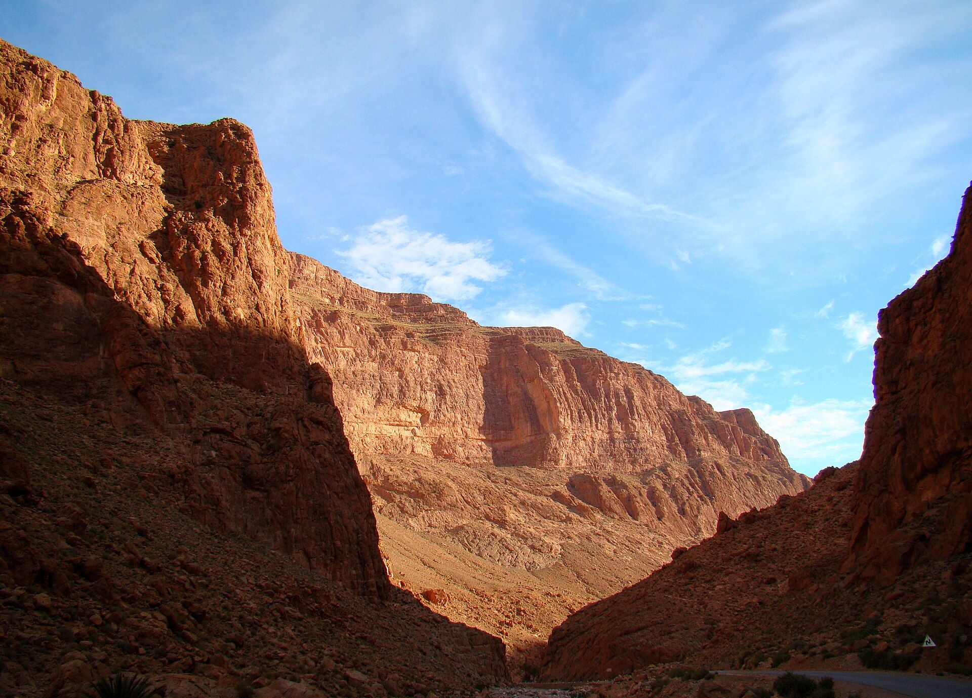
The Todgha (Todra) River, together with the neighbouring Dadès, has spent millennia sawing through the eastern High Atlas, cutting deep, cliff-sided canyons over their final kilometres out of the mountains. Todra's most dramatic reach is its last few hundred metres, where the smooth limestone walls rise as much as 160 m straight up while the floor pinches to barely ten metres across — a shaded, echoing corridor with a clear stream running through it and the sky reduced to a ribbon overhead. Above and below the narrows, the water feeds a green ribbon of palm groves and Berber villages threading the otherwise arid land. The sheer, featured walls have made Todra one of North Africa's premier sport-climbing destinations, laced with hundreds of bolted routes.
Why visit
Walking into the narrows is unforgettable — the temperature drops, the light turns to a glow high on the rock, and the canyon feels like a natural cathedral. It is an easy, accessible wonder reached on a short walk from the road, a natural stop on the route between the desert and the mountains, and a magnet for climbers and photographers.
More views of Todra Gorge
Additional photographs of the actual site — each freely licensed, with its photographer and licence credited.
What to know before you go
🗓️ Best time
Spring (March–May) and autumn (September–November) are ideal, with warm days and cool nights; summer middays are hot, and flash floods are possible after heavy rain or snowmelt. Winter nights are cold at altitude.
🧭 Getting there & access
The gorge is about 15 km north of Tinghir, itself roughly a day's drive from Marrakesh via the Tizi n'Tichka pass, or reached along the desert road from Ouarzazate and Erfoud. A surfaced road runs into the narrows.
Good to know
- Visit early or late to catch the light in the narrows and avoid tour-bus crowds at midday.
- Heed local guidance after rain or upstream snowmelt — the canyon floor can flash-flood.
- Dress modestly through the Berber villages and ask before photographing people.
Plan your visit
Easy🧭 Getting there
From Tinghir; Marrakesh (RAK) or Ouarzazate (OZZ) by road
- Drive from Marrakesh over the Tizi n'Tichka pass to Tinghir — roughly 7–8 hours
- From Tinghir, follow the valley road 15 km north into the gorge — about 30 minutes
- Total travel
- A long day's drive from Marrakesh; part of most desert-circuit itineraries
- Time at site
- A couple of hours for the narrows; longer to walk the valley or climb
- Access
- The gorge is open and free to enter; a road runs into the narrows with parking and cafes. Climbing is unregulated but best arranged with local guides and gear.
🎒 What to bring & consider
- Sturdy shoes for the rocky riverbed and any scrambling
- Layers — the narrows are shaded and cool even when the plateau is hot
- Water, sun protection and cash for village cafes
- Awareness of flash-flood risk after rain
👁️ What to expect
- Crowds
- Tour buses cluster at the narrows midday; mornings and evenings are calm.
- Conditions
- An easy, shaded canyon walk with a shallow stream; hot, dry country outside.
- Facilities
- Cafes and small hotels at the canyon mouth; villages with basic services nearby.
- The view
- Sunlight striking the upper walls while the floor stays in cool shadow.
Times and requirements are approximate and change with season, weather, and local rules — confirm permits, fares, and schedules with operators before you travel.
Natural riches of the area
- Sheer limestone canyon walls rising up to about 160 m above a narrow floor
- A spring-fed river that runs clear through the gorge year-round
- Palm-grove oases and irrigated Berber farmland along the valley
- Hundreds of bolted rock-climbing routes on the canyon walls
Local food
- Tagine
- Slow-cooked stew of meat or vegetables in a conical earthenware pot.
- Dates
- Harvested from the valley's palm oases, a staple of the pre-Sahara.
- Berber bread
- Round flatbread baked in village ovens, eaten with olive oil and honey.
Todra Gorge is one of Morocco’s most spectacular natural corridors — a slot canyon where the Todgha River has sawn straight down through the eastern High Atlas, leaving smooth limestone walls that rise as much as 160 metres while the floor narrows to barely ten metres across. Walk into that final reach and the world changes: the air cools, the noise of the outside falls away, and the sky shrinks to a bright ribbon far overhead.
The river that cut the gorge still runs clear along its floor, and where it emerges it feeds a green ribbon of palm groves and Berber villages winding through otherwise parched land — a vivid reminder of how completely water shapes life in the pre-Sahara. The contrast between the shaded, echoing narrows and the sun-baked plateau above is the essence of the place.
Reached on a short walk from the road about 15 kilometres north of Tinghir, Todra is both an easy stop on the classic desert-to-mountains circuit and a serious playground for climbers, its sheer walls threaded with hundreds of bolted routes that draw them from around the world.
Todra Gorge: common questions
How do you get to Todra Gorge?
From Tinghir; Marrakesh (RAK) or Ouarzazate (OZZ) by road: Drive from Marrakesh over the Tizi n'Tichka pass to Tinghir — roughly 7–8 hours; From Tinghir, follow the valley road 15 km north into the gorge — about 30 minutes. Total travel time: A long day's drive from Marrakesh; part of most desert-circuit itineraries.
When is the best time to visit Todra Gorge?
Spring (March–May) and autumn (September–November) are ideal, with warm days and cool nights; summer middays are hot, and flash floods are possible after heavy rain or snowmelt. Winter nights are cold at altitude.
How long should you spend at Todra Gorge?
A couple of hours for the narrows; longer to walk the valley or climb. Total travel time: A long day's drive from Marrakesh; part of most desert-circuit itineraries.
What should you bring to Todra Gorge?
Sturdy shoes for the rocky riverbed and any scrambling Layers — the narrows are shaded and cool even when the plateau is hot Water, sun protection and cash for village cafes Awareness of flash-flood risk after rain
Do you need a permit or guide for Todra Gorge?
The gorge is open and free to enter; a road runs into the narrows with parking and cafes. Climbing is unregulated but best arranged with local guides and gear.
Is Todra Gorge crowded, and what are conditions like?
Tour buses cluster at the narrows midday; mornings and evenings are calm. An easy, shaded canyon walk with a shallow stream; hot, dry country outside. Facilities: Cafes and small hotels at the canyon mouth; villages with basic services nearby.
Added
More wonders to explore