The Vjosa
📍 Southern Albania, from the Greek border to the Adriatic north of Vlorë
One of the last large rivers in Europe still allowed to behave like a river — braiding across its own gravel, moving its channels year to year, and undammed for 192 kilometres to the Adriatic.
What makes it marvelous
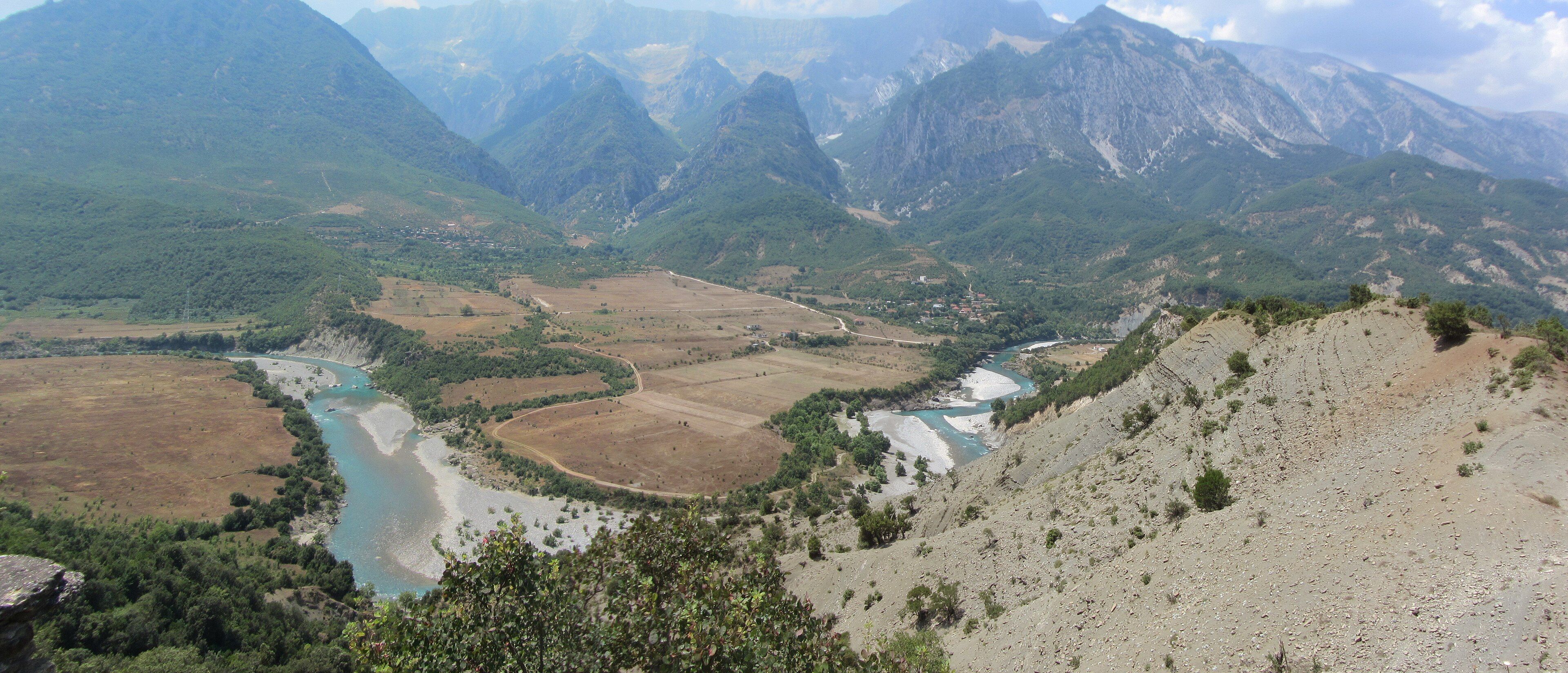
What makes the Vjosa remarkable is not a single feature but the absence of interference. Nearly every large river in Europe has been straightened, embanked, dammed or channelised, and in the process has lost the behaviour that defines a wild river: braiding into multiple channels, depositing and shifting gravel bars, carving new courses in flood and abandoning old ones. The Vjosa still does all of it. It rises in the Pindus mountains of Epirus in Greece, where it is called the Aoös, enters Albania near Çarshovë and runs 192 kilometres northwest to the Adriatic just above Vlorë without a single dam on its Albanian course. Total length is around 272 kilometres, the catchment 6,706 square kilometres, average discharge 195 cubic metres a second. In some reaches the braided channels spread across more than two kilometres of valley floor. On 15 March 2023, after a long campaign against a series of proposed hydropower schemes, Albania declared the river and its main tributaries the Vjosa Wild River National Park — the first national park in Europe created specifically to protect a wild river.
Why visit
You can see the braiding from the road. Around Përmet and Këlcyrë the valley opens out and the river spreads into pale turquoise channels across broad white gravel, with the Nemërçka and Trebeshina ranges standing over it — a landscape that most of Europe simply no longer has. There is rafting, kayaking and thermal bathing along it, and the villages of the upper valley are among the least developed in the Balkans.
What to know before you go
🗓️ Best time
May to June has strong flow from snowmelt and the best rafting; the gravel bars and swimming holes are at their best from July to September when the water is lower and warmer. Winter brings high, cold, fast water and rough weather in the upper valley.
🧭 Getting there & access
Përmet is the usual base for the upper river, roughly four hours by road from Tirana or three from Gjirokastër. The valley road follows the river from the Greek border down to the coast, with viewpoints along the way. Rafting and kayaking are arranged in Përmet and Këlcyrë; the delta and lagoons near Vlorë are reached separately.
Good to know
- Drive the stretch between Përmet and Këlcyrë slowly — the braided reaches are visible from the road and the pull-offs are unmarked.
- The Bënjë thermal springs sit beside the river near Përmet and are free to use.
- River levels change fast in spring; do not wade braided channels in high flow.
- The gravel bars are the habitat, not a car park. Drive on the road, not the bed.
Plan your visit
Easy🧭 Getting there
From Tirana (TIA), Albania
- Fly into Tirana
- Drive south to Gjirokastër or straight to Përmet
- Follow the valley road along the river between Përmet and Këlcyrë
- Continue downstream toward Tepelenë and the coast at Vlorë if you have time
- Total travel
- About 4 hours from Tirana to Përmet
- Time at site
- 2–4 days to see the upper valley properly
- Access
- The national park is open and free; there are no gates and very little signage yet, since the designation is recent. Rafting and kayaking are booked locally in Përmet and Këlcyrë. Roads in the upper valley are narrow and slow — allow considerably more time than the distances suggest.
🎒 What to bring & consider
- A car; public transport in the valley is sparse and slow
- Water shoes for the gravel and the thermal pools
- Cash in lek — card acceptance is limited outside the towns
- Sun protection; the gravel bars are fully exposed
- Patience with road surfaces that vary from good to unpaved
👁️ What to expect
- Crowds
- Light outside August. The upper valley sees far fewer visitors than the Albanian coast.
- Conditions
- Hot and dry in summer, cold and wet in winter. Easy roadside access; wading and rafting need care.
- Facilities
- Guesthouses, restaurants and outfitters in Përmet and Këlcyrë. Nothing on the gravel bars themselves.
- The view
- The braided channels from the high ground above Këlcyrë in the middle of the day, when the water shows its glacial turquoise against white gravel.
Times and requirements are approximate and change with season, weather, and local rules — confirm permits, fares, and schedules with operators before you travel.
Natural riches of the area
- 192 km of undammed river on the Albanian course, 272 km in total
- Braided channels and gravel bars that shift with every flood
- A catchment of 6,706 km² with an average discharge of 195 m³/s
- Free-flowing tributaries — the Voidomatis, Sarantaporos, Drino and Shushicë
- The Vjosa-Narta lagoons at the river's mouth on the Adriatic
Local food
- Përmet gliko
- Fruit preserved whole in syrup, the speciality of the upper valley.
- Tavë kosi
- Lamb baked under a yoghurt and egg custard, the Albanian national dish.
- Petulla
- Fried dough eaten with honey or salty cheese.
- Raki rrushi
- Grape brandy, distilled at home throughout the valley.
Rivers in Europe are mostly finished objects. They have been straightened, embanked, dredged, dammed and told where to go, and while many of them are still beautiful, they no longer do the things a river does when nobody is managing it: split into a dozen channels, pile up gravel, abandon one course in a flood and take another, flood the flats and drain them again.
The Vjosa still does. It rises in the Pindus mountains of Greek Epirus, where it is called the Aoös, crosses into Albania near Çarshovë, and runs 192 kilometres to the Adriatic just north of Vlorë without a single dam on the Albanian stretch. Along much of that length it is braided — several channels at once, threading between pale gravel bars that are in different places from one year to the next. In the wider reaches the active bed spreads across more than two kilometres of valley floor.
That survived a serious effort to end it. A series of hydropower schemes was proposed along the river through the 2010s, any one of which would have converted a free-flowing reach into a reservoir. A long campaign by Albanian and international conservation groups fought them, the government designated the Albanian course a managed nature reserve in December 2020, and on 15 March 2023 it went further and declared the river and its main tributaries the Vjosa Wild River National Park — the first park in Europe created specifically to keep a river wild.
For a visitor the appeal is unusually direct. The valley road follows the river, and between Përmet and Këlcyrë you can stand above the braided reaches and see the whole mechanism at once: turquoise water, white gravel, the Nemërçka range behind. There is rafting in spring, swimming in late summer, and thermal springs at Bënjë that run into the river itself. What there is not, remarkably for a European river valley, is very much of anything else.
The Vjosa: common questions
How do you get to The Vjosa?
From Tirana (TIA), Albania: Fly into Tirana; Drive south to Gjirokastër or straight to Përmet; Follow the valley road along the river between Përmet and Këlcyrë; Continue downstream toward Tepelenë and the coast at Vlorë if you have time. Total travel time: About 4 hours from Tirana to Përmet.
When is the best time to visit The Vjosa?
May to June has strong flow from snowmelt and the best rafting; the gravel bars and swimming holes are at their best from July to September when the water is lower and warmer. Winter brings high, cold, fast water and rough weather in the upper valley.
How long should you spend at The Vjosa?
2–4 days to see the upper valley properly. Total travel time: About 4 hours from Tirana to Përmet.
What should you bring to The Vjosa?
A car; public transport in the valley is sparse and slow Water shoes for the gravel and the thermal pools Cash in lek — card acceptance is limited outside the towns Sun protection; the gravel bars are fully exposed Patience with road surfaces that vary from good to unpaved
Do you need a permit or guide for The Vjosa?
The national park is open and free; there are no gates and very little signage yet, since the designation is recent. Rafting and kayaking are booked locally in Përmet and Këlcyrë. Roads in the upper valley are narrow and slow — allow considerably more time than the distances suggest.
Is The Vjosa crowded, and what are conditions like?
Light outside August. The upper valley sees far fewer visitors than the Albanian coast. Hot and dry in summer, cold and wet in winter. Easy roadside access; wading and rafting need care. Facilities: Guesthouses, restaurants and outfitters in Përmet and Këlcyrë. Nothing on the gravel bars themselves.
Added
More wonders to explore