Murchison Falls
📍 Murchison Falls National Park, northwestern Uganda
The Nile forced through a gap in the rock about 7 m wide before plunging some 43 m — the centrepiece of Uganda's largest national park.
What makes it marvelous
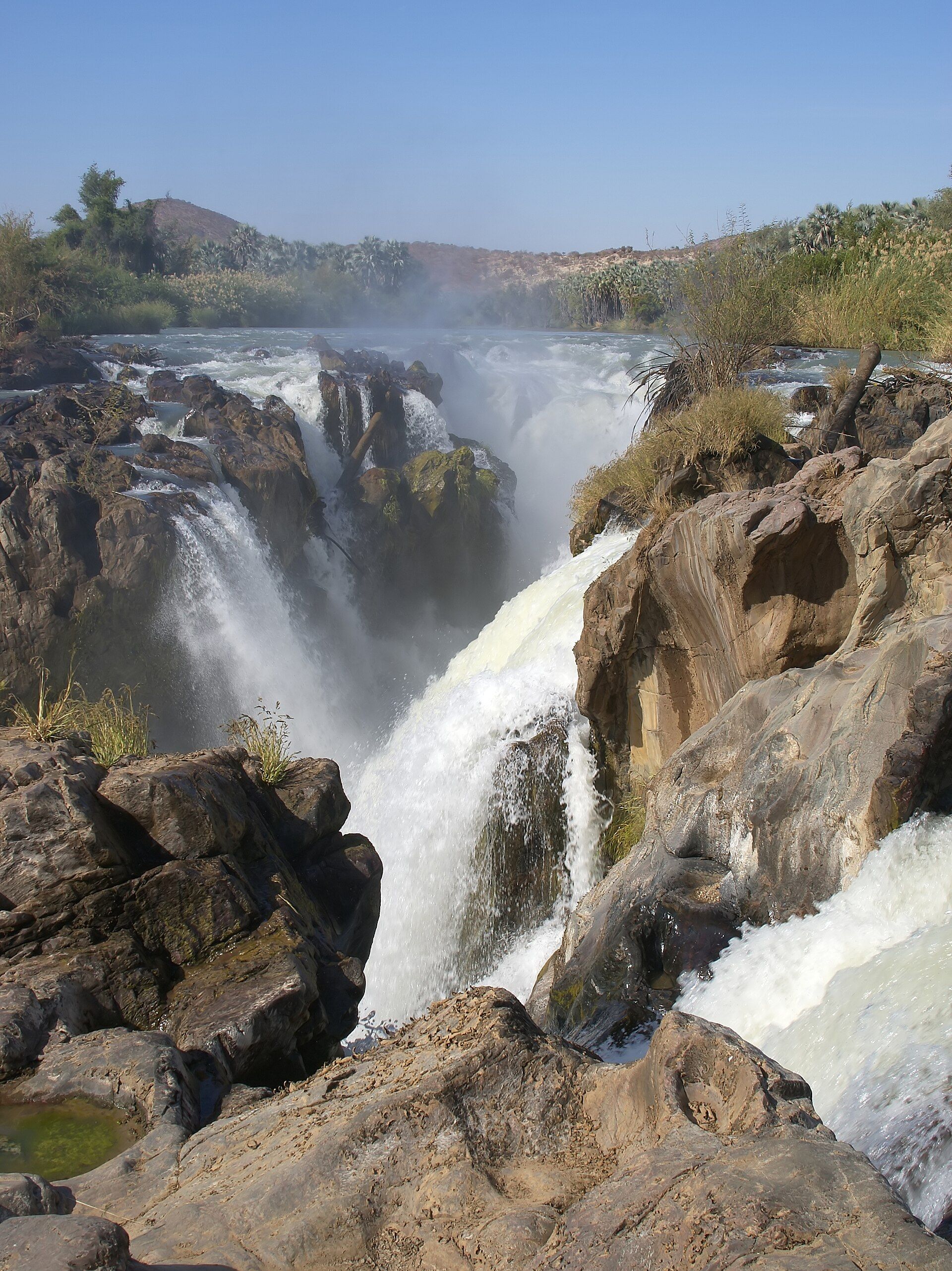
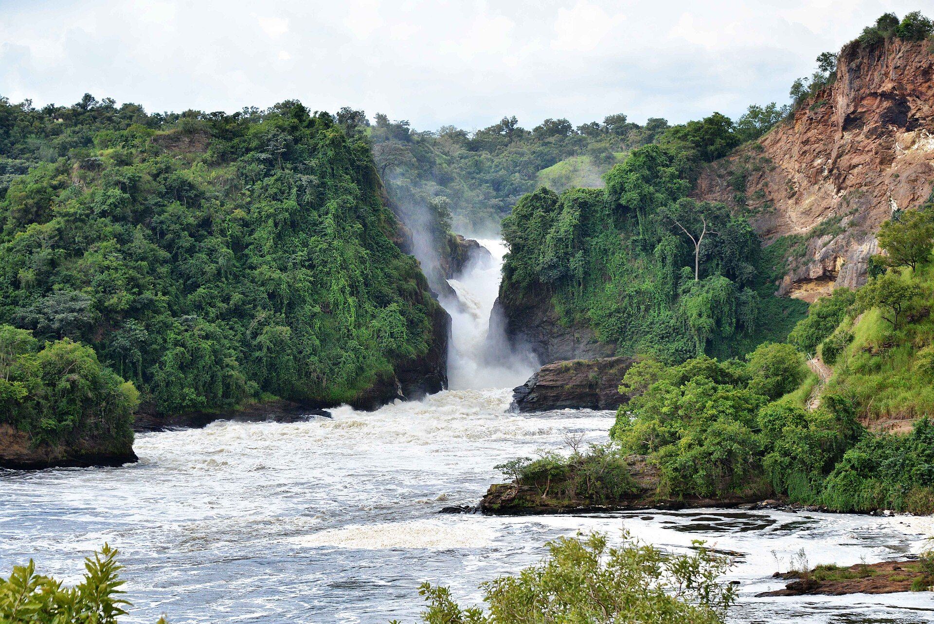
On its way to Lake Albert, the Victoria Nile is squeezed through a gorge only about 7 m (23 ft) wide and drops about 43 m (141 ft). The result is one of the most powerful-looking waterfalls in Africa: the whole river exploding through a slot in the rock in a roar of spray. Around it lies Murchison Falls National Park, at about 3,893 km² the largest national park in Uganda.
Why visit
You can stand at the top of the falls, a few metres from the full force of the Nile, then see the park's wildlife on the river and the savanna: Nile crocodiles — Uganda's largest population — Rothschild's giraffes and the prehistoric-looking shoebill.
What to know before you go
🗓️ Best time
The drier months are easiest for game drives and road travel; the falls run all year.
🧭 Getting there & access
The park lies in northwestern Uganda, with Masindi the nearest city. It is managed by the Uganda Wildlife Authority; most visitors arrive by road from Kampala or on an organised safari.
Good to know
- Walk to the top of the falls to feel the force of the river at the gap.
- Look for shoebills in the papyrus near the Nile delta at Lake Albert.
- Bring rain gear — the spray soaks everything near the top.
Plan your visit
Easy🧭 Getting there
From Entebbe (EBB), via Kampala
- Fly into Entebbe and transfer through Kampala
- Drive northwest via Masindi to the park
- Visit the top of the falls and the northern savanna by game drive
- Total travel
- A full day by road from Kampala
- Time at site
- 2–3 days
- Access
- Uganda Wildlife Authority park fees apply. A viewpoint at the top of the falls can be reached on foot; game drives and river trips are organised in the park.
🎒 What to bring & consider
- Rain gear for the spray at the top of the falls
- Binoculars for birds and game
- Insect repellent
- A guide or organised safari for game drives
👁️ What to expect
- Crowds
- Moderate; organised safaris visit year-round.
- Conditions
- Hot and humid; showers and muddy roads in the rains.
- Facilities
- Lodges and campsites in and around the park.
- The view
- The full Nile bursting through the gap from the viewpoint at the top.
Times and requirements are approximate and change with season, weather, and local rules — confirm permits, fares, and schedules with operators before you travel.
Natural riches of the area
- The Nile forced through a gap about 7 m wide
- Uganda's largest national park, about 3,893 km²
- Uganda's largest population of Nile crocodiles
- Rothschild's giraffe and the shoebill
Local food
- Rolex
- A chapati rolled around an omelette — Uganda's favourite street food.
- Matoke
- Steamed and mashed green bananas, the staple of Ugandan meals.
At Murchison Falls the longest river in Africa is squeezed into a space narrower than a city street. On its way to Lake Albert, the Victoria Nile funnels into a gorge only about 7 m wide and drops about 43 m, and the whole river explodes through the gap in a roar of white water and spray. Standing at the top, a few metres from the slot, is one of the most visceral experiences in African travel.
The falls give their name to Murchison Falls National Park, Uganda’s largest at about 3,893 km² and protected since 1952. Below the falls the river widens and slows, home to Uganda’s largest population of Nile crocodiles, and to the north open savanna holds Rothschild’s giraffes — some moved across the Nile in 2016 and 2017 to found a new herd — while the papyrus swamps near Lake Albert hide the shoebill, a giant, almost prehistoric-looking stork.
Most visitors combine a walk to the top of the falls with game drives on the northern savanna and a river trip on the Nile. Bring rain gear for the spray, and give the park at least two days.
Murchison Falls: common questions
How do you get to Murchison Falls?
From Entebbe (EBB), via Kampala: Fly into Entebbe and transfer through Kampala; Drive northwest via Masindi to the park; Visit the top of the falls and the northern savanna by game drive. Total travel time: A full day by road from Kampala.
When is the best time to visit Murchison Falls?
The drier months are easiest for game drives and road travel; the falls run all year.
How long should you spend at Murchison Falls?
2–3 days. Total travel time: A full day by road from Kampala.
What should you bring to Murchison Falls?
Rain gear for the spray at the top of the falls Binoculars for birds and game Insect repellent A guide or organised safari for game drives
Do you need a permit or guide for Murchison Falls?
Uganda Wildlife Authority park fees apply. A viewpoint at the top of the falls can be reached on foot; game drives and river trips are organised in the park.
Is Murchison Falls crowded, and what are conditions like?
Moderate; organised safaris visit year-round. Hot and humid; showers and muddy roads in the rains. Facilities: Lodges and campsites in and around the park.
Added
More wonders to explore