Mountain Pine Ridge
📍 Cayo District, western Belize
A highland of Caribbean pine on a granite massif in western Belize, cut by rivers that tumble over waterfalls and through the vast entrance of Rio Frio Cave.
What makes it marvelous
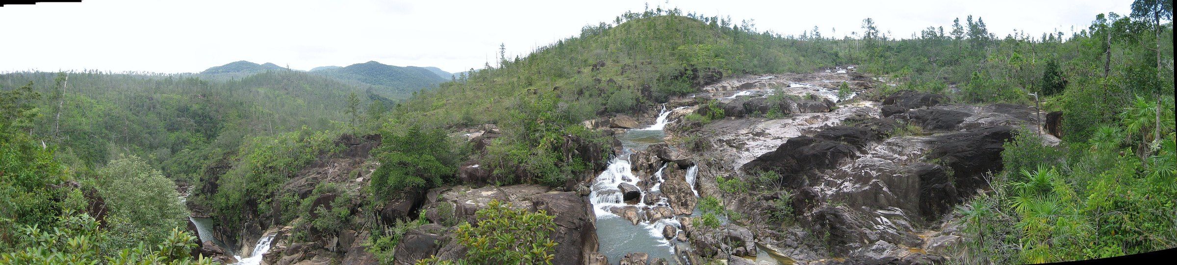
Mountain Pine Ridge Forest Reserve covers about 430 km² of Belize's Cayo District. Most of it sits on a granite massif at around 400–700 m — unusual in a country better known for limestone and reef — and pine forest, mainly Caribbean pine, covers more than half of it. Rivers falling off the massif form waterfalls such as Big Rock Falls on Privassion Creek and Hidden Valley Falls, and the Rio Frio runs through a cave with the largest entrance of any cave in Belize.
Why visit
It feels like a different country from the coast: cool pine uplands, granite boulders, swimming holes below waterfalls and caves, all within reach of San Ignacio.
What to know before you go
🗓️ Best time
The drier months, roughly February to May, for road access and swimming; roads can be muddy in the rains.
🧭 Getting there & access
The reserve lies in Cayo District in western Belize; Belmopan is the nearest city. Roads into the reserve are unpaved and best driven in a high-clearance vehicle.
Good to know
- Swim below Big Rock Falls, but take care on the rocks.
- Visit Rio Frio Cave for its huge entrance.
- Check road conditions after rain.
Plan your visit
Easy🧭 Getting there
From Belize City (BZE), via San Ignacio
- Fly into Belize City and drive west toward Belmopan and San Ignacio
- Turn south into the reserve on unpaved roads
- Visit waterfalls and Rio Frio Cave along the reserve roads
- Total travel
- Several hours by road from Belize City
- Time at site
- A full day; overnight at a lodge in the reserve
- Access
- Reserve roads are unpaved and can be rough after rain; some sites are reached by short walks from parking areas.
🎒 What to bring & consider
- A high-clearance vehicle or a guided tour
- Swimwear
- Insect repellent
👁️ What to expect
- Crowds
- Light outside the most popular waterfalls.
- Conditions
- Cooler than the lowlands; muddy roads in the rains.
- Facilities
- Lodges in and near the reserve; more in San Ignacio.
- The view
- White water cascading over dark granite between the pines.
Times and requirements are approximate and change with season, weather, and local rules — confirm permits, fares, and schedules with operators before you travel.
Natural riches of the area
- Caribbean pine forest on a granite massif
- Waterfalls including Big Rock Falls and Hidden Valley Falls
- Rio Frio Cave, Belize's largest cave entrance
- Baldy Beacon, 1,017 m
Local food
- Fry jacks
- Fried dough eaten with beans and eggs for a Belizean breakfast.
- Rice and beans
- The national staple, served with stewed chicken.
Most of Belize is limestone, jungle and reef. Mountain Pine Ridge is something else entirely: a granite upland in the Cayo District, at roughly 400 to 700 m, covered largely in Caribbean pine. Set aside as a forest reserve in 1944 and now about 430 km², it rises to 1,017 m at Baldy Beacon.
Water falling off the granite has shaped its best sights. Big Rock Falls drops over boulders on Privassion Creek into a deep swimming hole; Hidden Valley Falls is another of the reserve’s falls; and the Rio Frio flows through a cave whose entrance is the largest of any cave in Belize. The pine forest has suffered badly from southern pine beetle in the past, but it remains one of the country’s most distinctive landscapes.
The reserve is an easy trip from San Ignacio on unpaved roads. Go in the dry season, bring something to swim in, and check the roads after rain.
Mountain Pine Ridge: common questions
How do you get to Mountain Pine Ridge?
From Belize City (BZE), via San Ignacio: Fly into Belize City and drive west toward Belmopan and San Ignacio; Turn south into the reserve on unpaved roads; Visit waterfalls and Rio Frio Cave along the reserve roads. Total travel time: Several hours by road from Belize City.
When is the best time to visit Mountain Pine Ridge?
The drier months, roughly February to May, for road access and swimming; roads can be muddy in the rains.
How long should you spend at Mountain Pine Ridge?
A full day; overnight at a lodge in the reserve. Total travel time: Several hours by road from Belize City.
What should you bring to Mountain Pine Ridge?
A high-clearance vehicle or a guided tour Swimwear Insect repellent
Do you need a permit or guide for Mountain Pine Ridge?
Reserve roads are unpaved and can be rough after rain; some sites are reached by short walks from parking areas.
Is Mountain Pine Ridge crowded, and what are conditions like?
Light outside the most popular waterfalls. Cooler than the lowlands; muddy roads in the rains. Facilities: Lodges in and near the reserve; more in San Ignacio.
Added
More wonders to explore