Quebrada de Humahuaca
📍 Jujuy Province, northwestern Argentina
A long, arid mountain valley in Argentina's far northwest, walled by hillsides banded in reds, ochres, greens and purples — a UNESCO-listed cultural landscape carved by the Rio Grande and travelled for ten thousand years.
What makes it marvelous
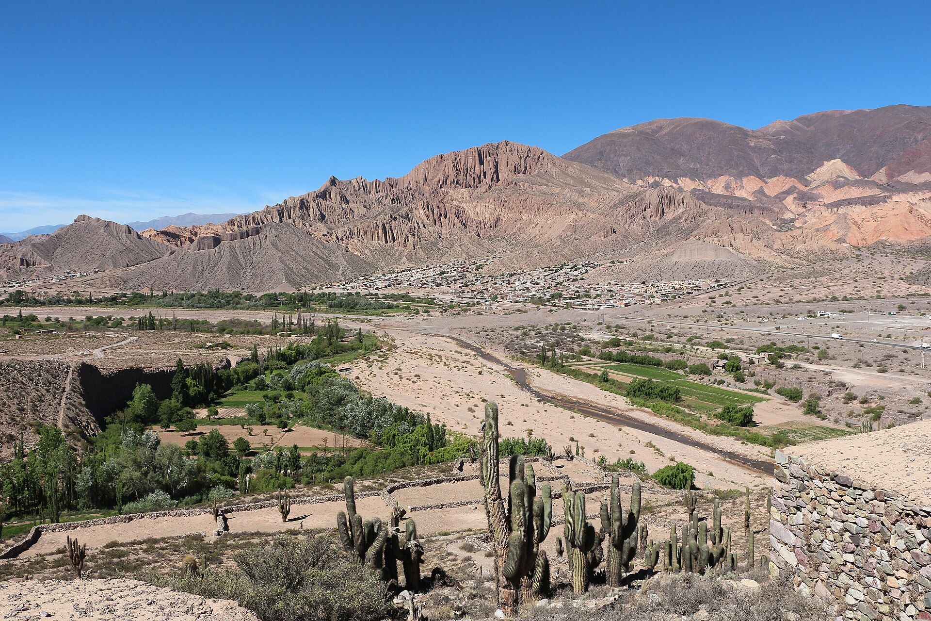
The Quebrada de Humahuaca is a narrow valley slicing north for some 150 kilometres along the Rio Grande, between the high Puna plateau and the wooded ranges to the east. Its walls are a geologist's colour chart: layer upon layer of marine and continental sediment, laid down over hundreds of millions of years and stained by different minerals, then lifted and tilted by the rise of the Andes. At Purmamarca the Cerro de los Siete Colores — the Hill of Seven Colours — rises straight behind the village, while near Humahuaca town the Serranía de Hornocal shows a jagged, zig-zag wall of fourteen shades at 4,350 metres. The valley has been a trade and travel corridor for 10,000 years, and carries the marks of hunter-gatherers, the Inca road, and later struggles for independence.
Why visit
Few landscapes are so vividly, improbably coloured — and few are so alive with human history. Adobe villages, salt flats, cactus-studded slopes and pre-Hispanic ruins line the route, and the light at dawn and dusk sets the mineral bands glowing. It is Argentina at its most Andean, closer in feel to Bolivia than to Buenos Aires.
More views of Quebrada de Humahuaca
Additional photographs of the actual site — each freely licensed, with its photographer and licence credited.
What to know before you go
🗓️ Best time
April to November is the dry season, with clear skies and cool, bright days; the summer months bring afternoon rain that can cut access to the high viewpoints.
🧭 Getting there & access
The valley is followed by National Route 9 north from the city of Jujuy through Purmamarca, Tilcara and Humahuaca; the Hornocal viewpoint is reached by a rough mountain road from Humahuaca town.
Good to know
- The valley sits at 2,000–3,000 m and the Hornocal viewpoint at 4,350 m — allow time to acclimatise and go easy at altitude.
- Best colour is early morning and late afternoon, when low light saturates the mineral bands.
- Carry warm layers for cold nights and cash for small mountain villages.
Plan your visit
Easy🧭 Getting there
From San Salvador de Jujuy (airport JUJ)
- Drive north from Jujuy on Route 9 to Purmamarca — about 1.5 hours
- Continue through Tilcara to Humahuaca, then up the mountain road to the Hornocal viewpoint
- Total travel
- About 1.5 hours to Purmamarca; a full day to travel the valley
- Time at site
- One to three days to see the villages and viewpoints
- Access
- The valley road is paved and open; the Hornocal viewpoint needs a rough high-altitude drive and is best with a guide or sturdy vehicle.
🎒 What to bring & consider
- Warm layers for cold nights and altitude
- Sun protection — the high-desert UV is strong
- Cash for village markets and viewpoint fees
- Time to acclimatise before the highest viewpoints
👁️ What to expect
- Crowds
- Purmamarca and Tilcara get busy midday; mornings and the wider valley stay calm.
- Conditions
- Dry, bright high-desert travel on good roads, with one rough climb to Hornocal.
- Facilities
- Hotels, cafes and craft markets in the main villages.
- The view
- The zig-zag ridge of Hornocal in late-afternoon light, or the Hill of Seven Colours behind Purmamarca at sunrise.
Times and requirements are approximate and change with season, weather, and local rules — confirm permits, fares, and schedules with operators before you travel.
Natural riches of the area
- Steeply tilted, mineral-stained sedimentary strata in dozens of colours
- The Rio Grande and its tributaries cutting the valley
- High-desert cardón cactus, and salt flats on the neighbouring Puna
- Llamas and vicuñas, herded and wild, on the surrounding heights
Local food
- Locro
- A hearty Andean stew of maize, squash and meat.
- Humita
- Fresh ground corn steamed in its own husk.
- Llama
- Lean Andean meat, often served grilled or in stews.
The Quebrada de Humahuaca is a ribbon of colour through Argentina’s far northwest — a long, dry valley following the Rio Grande for some 150 kilometres between the high Puna plateau and the eastern ranges of Jujuy Province. Its hillsides are banded in reds, ochres, greens and purples, the exposed edges of sediment laid down over hundreds of millions of years and then tilted skyward as the Andes rose, each layer stained a different shade by its minerals.
The valley’s set pieces are unforgettable: the Cerro de los Siete Colores, the Hill of Seven Colours, rising directly behind the adobe village of Purmamarca, and the Serranía de Hornocal near Humahuaca, a jagged wall of fourteen colours reached by a rough road to 4,350 metres. Dawn and dusk are the hours to see them, when low light deepens every band.
Yet the Quebrada is a cultural landscape as much as a geological one, which is why UNESCO inscribed it in 2003. For ten thousand years this has been a corridor of movement — for hunter-gatherers, for the Inca road, for independence-era armies — and its villages, ruins and terraced fields carry that long human story into a setting of extraordinary natural beauty.
Quebrada de Humahuaca: common questions
How do you get to Quebrada de Humahuaca?
From San Salvador de Jujuy (airport JUJ): Drive north from Jujuy on Route 9 to Purmamarca — about 1.5 hours; Continue through Tilcara to Humahuaca, then up the mountain road to the Hornocal viewpoint. Total travel time: About 1.5 hours to Purmamarca; a full day to travel the valley.
When is the best time to visit Quebrada de Humahuaca?
April to November is the dry season, with clear skies and cool, bright days; the summer months bring afternoon rain that can cut access to the high viewpoints.
How long should you spend at Quebrada de Humahuaca?
One to three days to see the villages and viewpoints. Total travel time: About 1.5 hours to Purmamarca; a full day to travel the valley.
What should you bring to Quebrada de Humahuaca?
Warm layers for cold nights and altitude Sun protection — the high-desert UV is strong Cash for village markets and viewpoint fees Time to acclimatise before the highest viewpoints
Do you need a permit or guide for Quebrada de Humahuaca?
The valley road is paved and open; the Hornocal viewpoint needs a rough high-altitude drive and is best with a guide or sturdy vehicle.
Is Quebrada de Humahuaca crowded, and what are conditions like?
Purmamarca and Tilcara get busy midday; mornings and the wider valley stay calm. Dry, bright high-desert travel on good roads, with one rough climb to Hornocal. Facilities: Hotels, cafes and craft markets in the main villages.
Added
More wonders to explore