McMurdo Dry Valleys
📍 Victoria Land, Antarctica
The largest ice-free area in Antarctica — around 4,500 square kilometres of bare rock and gravel where no significant snow or rain has fallen for close to two million years, and the closest thing on Earth to the surface of Mars.
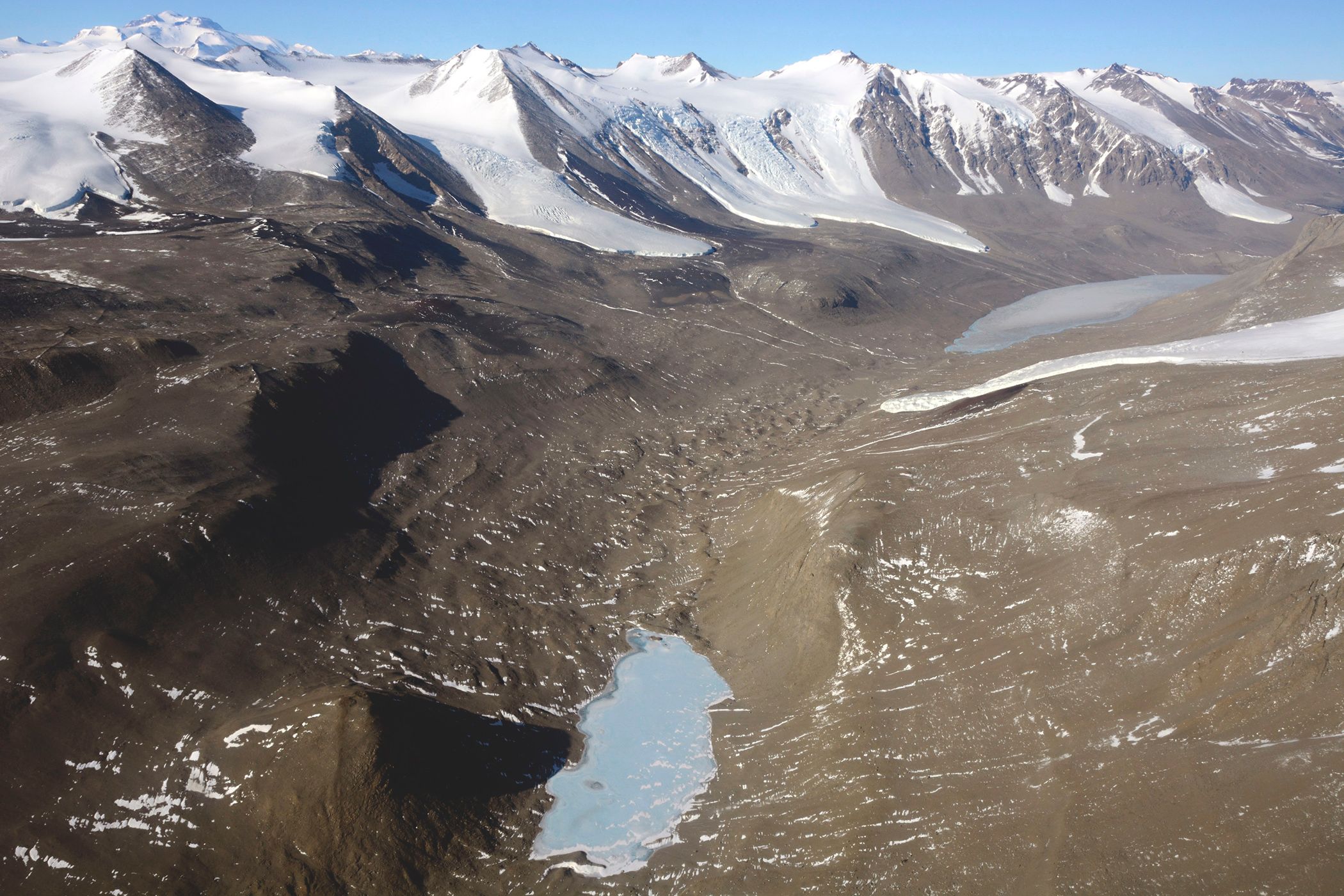
What makes it marvelous
The Dry Valleys are a hole in the ice sheet, and two mechanisms keep them open. The Transantarctic Mountains stand between the valleys and the East Antarctic Ice Sheet, blocking ice from flowing in. Then katabatic winds — dense, cold air draining off the polar plateau under gravity, accelerating to enormous speeds as it descends — sweep down the valleys and evaporate away what little moisture reaches them. The result is roughly 4,500 square kilometres of bare rock, about 0.03 per cent of the continent, and the coldest and driest desert on the planet: no meaningful precipitation for something on the order of two million years. What life there is survives inside the rock itself, in the pore spaces of sandstone, and in permanently ice-covered lakes fed by brief summer meltwater streams. Because of that combination of cold, aridity and salt chemistry, the valleys are the standard terrestrial analogue for Mars, and spacecraft have been tested here.
Why visit
Almost nobody does, and that is part of the point — this is one of the least accessible landscapes on Earth, reached by helicopter from research bases or on a small number of tightly managed expedition itineraries. What you get is a landscape with no ice, no snow, no vegetation and no soil in any ordinary sense: just rock, gravel, wind and frozen lakes, at a scale that reads as another planet.
What to know before you go
🗓️ Best time
The austral summer, roughly November to February, is the only practical window — it is the only period with continuous daylight, workable temperatures and any ship or air access at all. The valleys are effectively unreachable for the rest of the year.
🧭 Getting there & access
There is no independent access. Visits are by helicopter from the Ross Sea research bases or as part of a small number of permitted expedition-cruise itineraries, and are limited by an environmental code of conduct under the Antarctic Treaty. The region is an Antarctic Specially Managed Area with strict rules on where people may walk.
Good to know
- Treat this as an expedition, not a trip — access depends on weather, aircraft and permits.
- Ross Sea itineraries are far longer and costlier than Antarctic Peninsula voyages.
- Follow the walking restrictions exactly; footprints in this ground can persist for decades.
- Expect plans to change. Helicopter operations here are cancelled by wind routinely.
Plan your visit
Expedition🧭 Getting there
From Christchurch (CHC), New Zealand, or Hobart, for Ross Sea departures
- Reach Christchurch or Hobart
- Join a Ross Sea expedition voyage, or travel as part of a research programme
- Sail several days south across the Southern Ocean
- Access the valleys by helicopter when weather permits
- Total travel
- Ross Sea voyages typically run three to four weeks door to door
- Time at site
- Hours, if the weather allows a landing at all
- Access
- No independent travel. Access is via national research programmes or a small number of permitted expedition operators, governed by the Antarctic Treaty and an Antarctic Specially Managed Area plan. Landings are weather-dependent and frequently cancelled.
🎒 What to bring & consider
- Full polar clothing supplied and checked by the operator or programme
- Genuine schedule flexibility, since helicopter access fails more often than it succeeds
- Strict adherence to the walking and waste rules, which are legally binding here
- Sun and wind protection — the air is dry, the light is intense and the wind is constant
- Comprehensive expedition insurance including evacuation
👁️ What to expect
- Crowds
- Effectively none. Visitor numbers here are among the lowest of any named landscape on Earth.
- Conditions
- Extremely dry, extremely cold, and frequently very windy. Bare rock and loose gravel underfoot.
- Facilities
- None whatsoever beyond research infrastructure, which is not open to visitors.
- The view
- The valley floors under low summer sun, with ice-covered lakes and the Transantarctic Mountains behind — no snow anywhere in the frame.
Times and requirements are approximate and change with season, weather, and local rules — confirm permits, fares, and schedules with operators before you travel.
Natural riches of the area
- The largest ice-free region in Antarctica, around 4,500 km²
- Katabatic winds draining off the polar plateau at extreme speed
- Permanently ice-covered lakes fed by brief summer meltwater
- Endolithic microbial communities living inside sandstone
- The closest terrestrial analogue to the Martian surface
Local food
- Expedition rations
- There is no local food source — everything is flown or shipped in and waste is removed.
Antarctica is almost entirely buried, which makes the McMurdo Dry Valleys genuinely strange: around 4,500 square kilometres of bare rock and gravel, roughly 0.03 per cent of the continent, with no ice sheet on top of it. Two things keep them clear. The Transantarctic Mountains sit between the valleys and the East Antarctic Ice Sheet and physically block the ice from flowing down. And katabatic winds — dense cold air sliding off the high polar plateau under its own weight, picking up enormous speed on the way down — scour the valleys and evaporate away what little moisture arrives.
The result is the coldest and driest desert on the planet, with no significant precipitation for something on the order of two million years. Life persists, but barely and strangely: microbial communities live inside the pore spaces of sandstone rather than on it, and a handful of permanently ice-capped lakes are fed by meltwater streams that run for a few weeks each summer. That combination of extreme cold, extreme aridity and salt-rich soil chemistry is why the valleys serve as the standard Earth analogue for Mars, and why spacecraft instruments have been field-tested here before being sent to look for the same conditions elsewhere.
McMurdo Dry Valleys: common questions
How do you get to McMurdo Dry Valleys?
From Christchurch (CHC), New Zealand, or Hobart, for Ross Sea departures: Reach Christchurch or Hobart; Join a Ross Sea expedition voyage, or travel as part of a research programme; Sail several days south across the Southern Ocean; Access the valleys by helicopter when weather permits. Total travel time: Ross Sea voyages typically run three to four weeks door to door.
When is the best time to visit McMurdo Dry Valleys?
The austral summer, roughly November to February, is the only practical window — it is the only period with continuous daylight, workable temperatures and any ship or air access at all. The valleys are effectively unreachable for the rest of the year.
How long should you spend at McMurdo Dry Valleys?
Hours, if the weather allows a landing at all. Total travel time: Ross Sea voyages typically run three to four weeks door to door.
What should you bring to McMurdo Dry Valleys?
Full polar clothing supplied and checked by the operator or programme Genuine schedule flexibility, since helicopter access fails more often than it succeeds Strict adherence to the walking and waste rules, which are legally binding here Sun and wind protection — the air is dry, the light is intense and the wind is constant Comprehensive expedition insurance including evacuation
Do you need a permit or guide for McMurdo Dry Valleys?
No independent travel. Access is via national research programmes or a small number of permitted expedition operators, governed by the Antarctic Treaty and an Antarctic Specially Managed Area plan. Landings are weather-dependent and frequently cancelled.
Is McMurdo Dry Valleys crowded, and what are conditions like?
Effectively none. Visitor numbers here are among the lowest of any named landscape on Earth. Extremely dry, extremely cold, and frequently very windy. Bare rock and loose gravel underfoot. Facilities: None whatsoever beyond research infrastructure, which is not open to visitors.
Added
More wonders to explore