Masungi Georeserve
📍 Baras, Rizal, Philippines
A dramatic limestone karst landscape barely 90 minutes from Manila, reborn as a conservation project — jagged rock formations, rope courses, and hanging viewpoints woven through a rainforest being restored tree by tree.
What makes it marvelous
Masungi's rocks are ancient marine limestone, sixty million years old, dissolved and sharpened by rain into a maze of pinnacles, ravines, and caves. Once threatened by quarrying and illegal logging, the area is now a privately managed reserve where a non-profit is restoring the surrounding watershed with native trees — an award-winning model of turning a degraded landscape back into forest.
Why visit
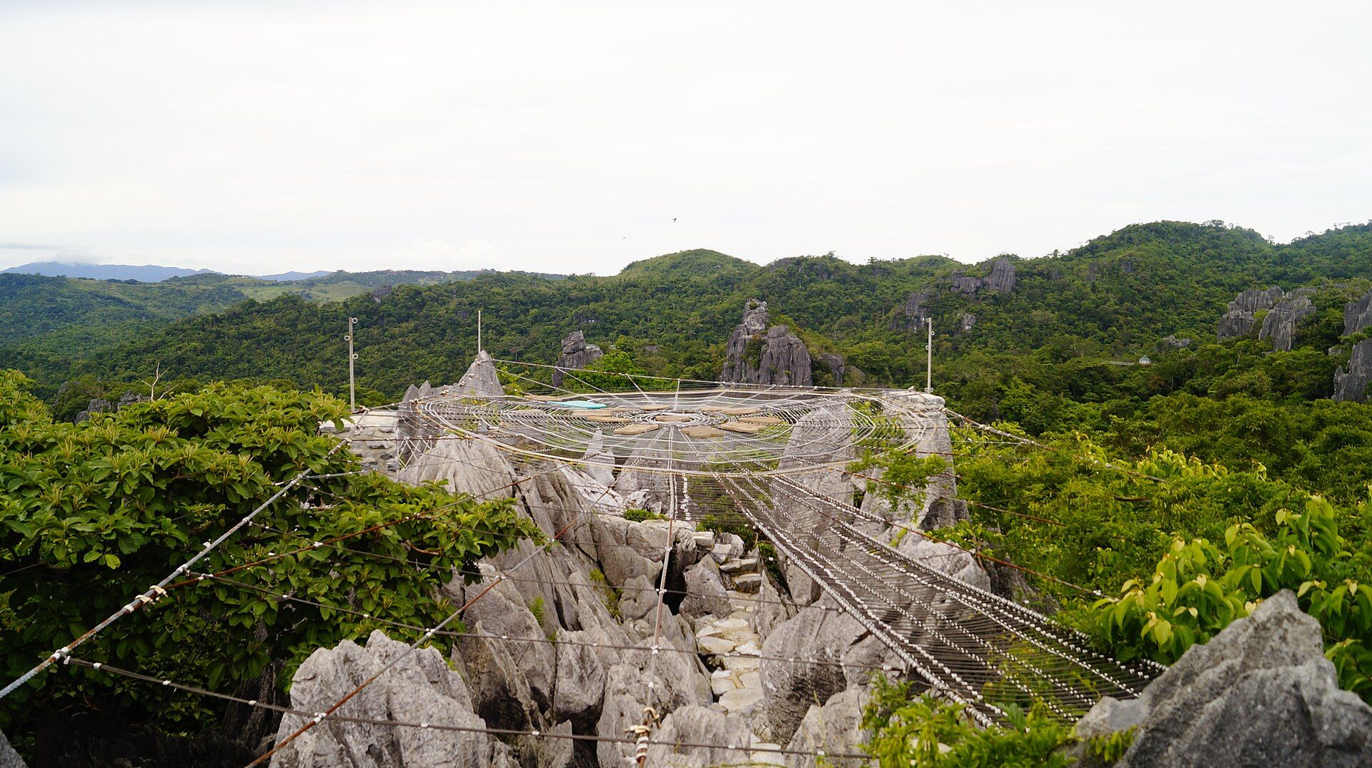
The Discovery Trail routes you through the karst on carved steps, rope bridges, and a giant web-like viewing platform strung between rock towers, with the Sierra Madre rolling away in every direction. It is adventure and conservation in one — you literally walk through a landscape being brought back to life.
What to know before you go
🗓️ Best time
November to May, the dry season, for safe footing on the rock and rope courses. Trails may close during heavy rain.
🧭 Getting there & access
About 1.5 hours by car east of Manila to Baras, Rizal, along the Marcos Highway. Reservations are strictly required and there are no walk-ins — book well ahead through the official Masungi site.
Good to know
- Book far in advance — slots are limited and walk-ins are turned away.
- Wear closed shoes with grip; the trail involves climbing and rope courses.
- This is a conservation area first — stay on the trail and support the restoration.
Plan your visit
Moderate🧭 Getting there
From Metro Manila, via Baras, Rizal
- Drive Manila → Marcos Highway (Marilaque) → Baras — roughly 1h30–2h30 depending badly on traffic getting out of the metro
- Arrive at the reserve gate for your booked time slot
- Total travel
- Two hours from Manila on a good morning, three on a bad one
- Time at site
- About 3–4 hours for the Discovery Trail
- Access
- Strictly by advance booking with a conservation fee and a fixed time slot — there are no walk-ins, and turning up hoping for a space does not work. Slots are limited and weekend dates go weeks ahead. The reserve has also been the subject of ongoing land disputes and has closed or altered its trails at short notice; check the georeserve's own channels for current status before you drive out.
🎒 What to bring & consider
- Closed-toe shoes with grip — required, and enforced at the gate. Sandals will end your visit before it starts
- A head for heights, because the trail crosses rope nets and steel walkways suspended over sharp limestone with real drops beneath
- A small bag only: large packs do not work on the rope structures and there are weight and health restrictions on the hanging sections
- Water and a hat for exposed karst that reflects heat back at you, with little shade on the upper viewpoints
- An early slot, since the afternoon brings both heat and, in the wet season, reliable thunderstorms
👁️ What to expect
- Crowds
- Managed by design — small groups on staggered slots with a guide, so it never feels busy despite being close to Manila.
- Conditions
- Continuous scrambling, ladders and rope courses over jagged karst for several hours. More physical than the photographs suggest.
- Facilities
- Well organised: guides, rest points, a café at the end. No facilities out on the trail itself.
- The view
- The spiderweb rope net strung between limestone spires, with the Sierra Madre behind. Everyone photographs it, and you will be photographed on it — the guides are practised at taking the picture for you.
Times and requirements are approximate and change with season, weather, and local rules — confirm permits, fares, and schedules with operators before you travel.
Natural riches of the area
- 60-million-year-old limestone karst pinnacles and caves
- Regenerating Sierra Madre rainforest and watershed
- Native trees replanted across former degraded land
- Springs and streams feeding reservoirs that supply Metro Manila
Local food
- Rizal kesong puti
- Soft white carabao-milk cheese from the province, eaten with bread (pandesal).
- Suman & kakanin
- Sticky rice cakes and coconut sweets from the local towns.
- Highland coffee & tablea
- Locally grown coffee and native chocolate served at the reserve and nearby towns.
Masungi packs a great deal into a short drive from Manila. Its limestone karst is sixty million years old — an ancient seabed lifted and then carved by rain into a bristling maze of pinnacles, ravines, and caves. The Discovery Trail leads you through it on carved steps, rope bridges, and a famous web-like platform slung between rock towers, with the Sierra Madre spreading to the horizon.
What lifts Masungi beyond adventure is its story. The area was once scarred by quarrying and illegal logging; today a non-profit runs it as a reserve and is painstakingly restoring the surrounding watershed with native trees. The work has won international recognition as a model for regenerating degraded land — and for protecting the forests that feed Metro Manila’s water.
Because the restoration comes first, access is deliberately limited and reservation-only. Booking ahead and staying on the trail isn’t red tape; it’s how a fragile, recovering landscape stays that way.
Masungi Georeserve: common questions
How do you get to Masungi Georeserve?
From Metro Manila, via Baras, Rizal: Drive Manila → Marcos Highway (Marilaque) → Baras — roughly 1h30–2h30 depending badly on traffic getting out of the metro; Arrive at the reserve gate for your booked time slot. Total travel time: Two hours from Manila on a good morning, three on a bad one.
When is the best time to visit Masungi Georeserve?
November to May, the dry season, for safe footing on the rock and rope courses. Trails may close during heavy rain.
How long should you spend at Masungi Georeserve?
About 3–4 hours for the Discovery Trail. Total travel time: Two hours from Manila on a good morning, three on a bad one.
What should you bring to Masungi Georeserve?
Closed-toe shoes with grip — required, and enforced at the gate. Sandals will end your visit before it starts A head for heights, because the trail crosses rope nets and steel walkways suspended over sharp limestone with real drops beneath A small bag only: large packs do not work on the rope structures and there are weight and health restrictions on the hanging sections Water and a hat for exposed karst that reflects heat back at you, with little shade on the upper viewpoints An early slot, since the afternoon brings both heat and, in the wet season, reliable thunderstorms
Do you need a permit or guide for Masungi Georeserve?
Strictly by advance booking with a conservation fee and a fixed time slot — there are no walk-ins, and turning up hoping for a space does not work. Slots are limited and weekend dates go weeks ahead. The reserve has also been the subject of ongoing land disputes and has closed or altered its trails at short notice; check the georeserve's own channels for current status before you drive out.
Is Masungi Georeserve crowded, and what are conditions like?
Managed by design — small groups on staggered slots with a guide, so it never feels busy despite being close to Manila. Continuous scrambling, ladders and rope courses over jagged karst for several hours. More physical than the photographs suggest. Facilities: Well organised: guides, rest points, a café at the end. No facilities out on the trail itself.
Added Updated
More wonders to explore