Karijini National Park
📍 Hamersley Range, Pilbara, Western Australia, about 1,400 km north of Perth
Western Australia's second-largest national park: more than 627,000 hectares of the Pilbara's Hamersley Range, where creeks plunge into 100-metre gorges cut through banded iron rock and hide waterfalls, ferny pools and narrow chasms.
What makes it marvelous
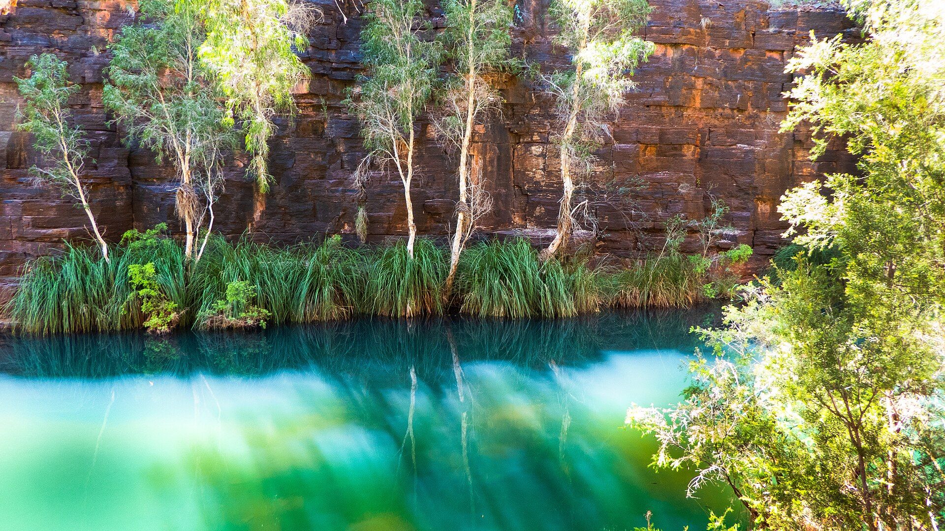
Karijini protects more than 627,000 hectares of the Hamersley Range in the Pilbara — the Banyjima name for the range is Karijini. The banded iron formations exposed in its gorges began more than 2,500 million years ago as iron- and silica-rich sediment on an ancient sea floor. Buried and compressed into tough, well-bedded rock, the layers later buckled and cracked vertically before being lifted into dry land; when sea level dropped sharply, rivers cut rapidly down through them and carved sheer-sided gorges. In the north of the park, small creek beds that are dry for most of the year suddenly plunge into 100-metre chasms, then widen downstream until they spill out as alluvial fans into the Fortescue Valley. Down in the gorges are permanent waterfalls and pools: Fortescue Falls and Fern Pool in Dales Gorge, Kermits Pool at the end of Hancock Gorge, and Handrail Pool in Weano Gorge. Above them, Punurrunha (Mount Bruce) is the second-tallest peak in Western Australia.
Why visit
Climb down between banded red walls to swim in clear, cold gorge pools, edge through Hancock Gorge to Kermits Pool, and look down from Oxer Lookout into the gorges of the Weano area — then camp under an outback sky full of stars.
What to know before you go
🗓️ Best time
The cooler months, roughly May to September, are best for hiking: Parks and Wildlife says temperatures can regularly exceed 50°C from November to April, and summer days frequently top 40°C. Gorge water is very cold, especially between April and September, so a wetsuit helps for longer swims. The mainly summer rain often comes with thunderstorms and cyclones, bringing flash-flood risk in the gorges.
🧭 Getting there & access
Karijini is about 1,400 km north of Perth. The nearest airports are Paraburdoo, about 100 km from the park, and Newman, 263 km away; both have hire cars. The closest fuel is at Tom Price, 80 km west of the park, and there is none inside it. The Karijini Visitor Centre lies just off Banjima Drive in the eastern section and is closed from early December to early February. Gravel roads in the park can be washed out and closed after heavy rain.
Good to know
- Never enter a gorge if rain is about, and leave at once if it starts raining while you are in one — flash floods can occur.
- Blue asbestos is present in Yampire and Wittenoom Gorges; asbestos dust can cause cancer if inhaled, so stay out of them.
- Carry 3 to 4 litres of water per person per day and hike in the cooler months or first thing in the morning.
- Hancock Gorge, Handrail Pool and Joffre Falls are Class 5 trails with scrambling and wading — wear grippy footwear and expect to get wet.
- Dingoes are common around Dales Campground: never feed them, and store food in your vehicle.
Plan your visit
Moderate🧭 Getting there
From Paraburdoo (PBO), about 100 km from the park; Newman (ZNE) is 263 km away
- Fly to Paraburdoo or Newman, usually via Perth, and pick up a hire car
- Refuel at Tom Price, 80 km west of the park — there is no fuel inside it
- Drive to the Karijini Visitor Centre off Banjima Drive, then on to the Dales and Weano recreation areas
- Total travel
- About 1,400 km from Perth overall; a flight to Paraburdoo plus around 100 km by road
- Time at site
- Two to three nights to see Dales Gorge and the Weano area's gorges; add a day for Mount Bruce or the more remote Hamersley Gorge in the north-west
- Access
- Park entry fees apply — confirm current fees and passes with Parks and Wildlife Service WA (exploreparks.dbca.wa.gov.au). Online booking is mandatory for Dales Campground (parkstay.dbca.wa.gov.au); Karijini Eco Retreat near Joffre Gorge offers other accommodation, and guests still pay park entry. Class 5 trails involve climbing, scrambling and swimming. Gravel roads may close after heavy rain, and the visitor centre is closed from early December to early February.
🎒 What to bring & consider
- 3 to 4 litres of water per person per day
- A full fuel tank from Tom Price
- Footwear with good grip for wet rock, and swimwear or a wetsuit for cold pools
- A personal locator beacon or satellite phone — mobile coverage is limited
- Sun protection and a first-aid kit
👁️ What to expect
- Crowds
- Busiest in the cooler peak season from about April to October; quieter in summer, when heat is extreme.
- Conditions
- Rim walks and lookouts are short and moderate; trails into the gorges involve steep steps, rock hopping, scrambling and wading through cold water.
- Facilities
- Visitor centre with toilets and showers, Dales Campground, the Karijini Eco Retreat and an overflow campground in peak season; no fuel or shops in the park.
- The view
- The turquoise pool beneath Fortescue Falls, framed by stepped layers of red banded iron rock.
Times and requirements are approximate and change with season, weather, and local rules — confirm permits, fares, and schedules with operators before you travel.
Natural riches of the area
- Banded iron formations more than 2,500 million years old
- Dales, Hancock, Weano, Joffre, Knox and Hamersley gorges
- Fortescue Falls, Fern Pool, Kermits Pool and Handrail Pool
- Punurrunha (Mount Bruce), the second-tallest peak in Western Australia
- Spinifex grasslands, mulga woodlands and termite mounds
- Red kangaroos, euros and Rothschild's rock-wallabies
Local food
- Bush tucker
- Native foods of the Pilbara, including bush fruits and seeds gathered from the arid country.
- Outback beef
- Cattle raised on the vast pastoral stations of the Pilbara.
Karijini is Western Australia’s second-largest national park, more than 627,000 hectares of the Hamersley Range in the heart of the Pilbara, about 1,400 kilometres north of Perth. The park is the traditional home of the Banyjima, Kurrama and Innawonga people, and Karijini is the Banyjima name for the range. On top is a high, dry plateau of spinifex and scattered eucalypts. Below it are the gorges.
The rock in their walls is banded iron formation. It began more than 2,500 million years ago as iron- and silica-rich sediment on an ancient sea floor, was compressed into hard, well-bedded layers, and was later buckled, cracked and lifted into dry land. When sea level dropped sharply, rivers cut fast down through it. In the north of the park, small creeks that are dry most of the year suddenly fall into chasms about 100 metres deep, then widen downstream before running out into the Fortescue Valley.
The gorges hold permanent water. In Dales Gorge, Fortescue Falls spills over stepped red ledges, and Fern Pool is a short detour away. In Hancock Gorge, a Class 5 trail for fit, experienced hikers leads to Kermits Pool, and in Weano Gorge a climb down through steep, narrow passages reaches Handrail Pool. From Knox Lookout you can see where Knox Gorge meets Wittenoom Gorge. Punurrunha (Mount Bruce), the second-tallest peak in the state, rises about 36 kilometres west of the ranger’s office.
This is hard country, and Parks and Wildlife is blunt about it. Summer days frequently top 40°C. Flash floods can fill gorges when rain falls in the area. The pools are cold enough to cause hypothermia, and blue asbestos is present in Yampire and Wittenoom Gorges. Come between May and September, fill the tank at Tom Price, book Dales Campground in advance, and carry plenty of water.
Karijini National Park: common questions
How do you get to Karijini National Park?
From Paraburdoo (PBO), about 100 km from the park; Newman (ZNE) is 263 km away: Fly to Paraburdoo or Newman, usually via Perth, and pick up a hire car; Refuel at Tom Price, 80 km west of the park — there is no fuel inside it; Drive to the Karijini Visitor Centre off Banjima Drive, then on to the Dales and Weano recreation areas. Total travel time: About 1,400 km from Perth overall; a flight to Paraburdoo plus around 100 km by road.
When is the best time to visit Karijini National Park?
The cooler months, roughly May to September, are best for hiking: Parks and Wildlife says temperatures can regularly exceed 50°C from November to April, and summer days frequently top 40°C. Gorge water is very cold, especially between April and September, so a wetsuit helps for longer swims. The mainly summer rain often comes with thunderstorms and cyclones, bringing flash-flood risk in the gorges.
How long should you spend at Karijini National Park?
Two to three nights to see Dales Gorge and the Weano area's gorges; add a day for Mount Bruce or the more remote Hamersley Gorge in the north-west. Total travel time: About 1,400 km from Perth overall; a flight to Paraburdoo plus around 100 km by road.
What should you bring to Karijini National Park?
3 to 4 litres of water per person per day A full fuel tank from Tom Price Footwear with good grip for wet rock, and swimwear or a wetsuit for cold pools A personal locator beacon or satellite phone — mobile coverage is limited Sun protection and a first-aid kit
Do you need a permit or guide for Karijini National Park?
Park entry fees apply — confirm current fees and passes with Parks and Wildlife Service WA (exploreparks.dbca.wa.gov.au). Online booking is mandatory for Dales Campground (parkstay.dbca.wa.gov.au); Karijini Eco Retreat near Joffre Gorge offers other accommodation, and guests still pay park entry. Class 5 trails involve climbing, scrambling and swimming. Gravel roads may close after heavy rain, and the visitor centre is closed from early December to early February.
Is Karijini National Park crowded, and what are conditions like?
Busiest in the cooler peak season from about April to October; quieter in summer, when heat is extreme. Rim walks and lookouts are short and moderate; trails into the gorges involve steep steps, rock hopping, scrambling and wading through cold water. Facilities: Visitor centre with toilets and showers, Dales Campground, the Karijini Eco Retreat and an overflow campground in peak season; no fuel or shops in the park.
Added
More wonders to explore