Nature route · Full loop
Madagascar: Tsingy, Baobabs & the Road South
The Avenue of the Baobabs, the razor-edged Tsingy de Bemaraha, then south on the RN7 to Ranomafana's rainforest lemurs and Isalo's sandstone canyons — Madagascar's west and south in 15 days.
A fifteen-day dry-season route: fly to Morondava for the Avenue of the Baobabs and a rough two-day round trip to the Tsingy de Bemaraha, then drive the RN7 south to Ranomafana's rainforest and Isalo's canyons, and fly home from Toliara.
- Length 15 days
- Stops 4 wonders
- Budget $1,600–5,400 pp
- Region Menabe & Melaky in the west, the RN7 through the highlands to the south-west, Madagascar
Trip map
The route
Stops in travel order — tap any one for the full wonder guide.
-
Avenue of the Baobabs 2 nights
Menabe, western Madagascar
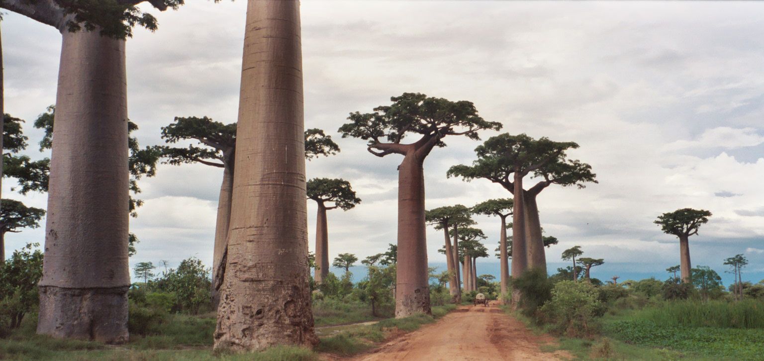
Grandidier's baobabs up to about 30 m tall lining a dirt road 30–45 minutes from Morondava — best at sunset and, far quieter, at dawn.
-
Tsingy de Bemaraha 3 nights
Melaky, western Madagascar
Knife-edged limestone pinnacles crossed on guided circuits with ladders, rope bridges and harnesses, based at Bekopaka — dry season only.
-
Ranomafana National Park 2 nights
Southeastern Madagascar, near Ranomafana town
Montane rainforest on the eastern escarpment with thirteen lemur species, including the golden bamboo lemur; guides are required at all times.
-
Isalo National Park 3 nights
Ihorombe Region, southwestern Madagascar, near Ranohira
A sandstone massif cut into canyons up to 200 m deep, with natural pools to swim in and ring-tailed lemurs, based at Ranohira.
Day by day
-
Arrive in Antananarivo
Base Antananarivo
Arrive and rest. If you are travelling with a driver-guide for the RN7 half, confirm the plan and the vehicle now.
-
Fly west to Morondava
Base Morondava
- Fly Antananarivo to Morondava — about an hour (the road takes roughly 8–12 hours)
- Morondava to the Avenue of the Baobabs on the RN8 — about 30–45 minutes
Time the drive out for sunset, when the trunks of the great baobabs glow against the sky. Expect a crowd right at sunset; a local guide and a small community fee are usual.
-
The long track to Bekopaka
Base Bekopaka
- Morondava to Bekopaka by 4x4 — about 8–10 hours on very rough track, with two river ferry crossings
Leave before dawn and stop at the Avenue of the Baobabs for a far quieter sunrise. The rest of the day is the drive itself — among the roughest routes visitors commonly travel anywhere.
-
Tsingy de Bemaraha
Base Bekopaka
- Bekopaka to the Grand Tsingy — a further 1–2 hours by 4x4
Two days with a mandatory local guide, arranged at the park office: one on a Grand Tsingy circuit, with a harness and via ferrata clipping supplied and supervised by the guides, and one on shorter routes near Bekopaka or a pirogue trip through the Manambolo gorge. Wear hard-soled boots and gloves — the rock is sharp enough to cut.
-
Back to Morondava
Base Morondava
- Bekopaka to Morondava — about 8–10 hours, with the same two river crossings
Another long day on the track, timed if you can for a last look at the baobabs in the evening light.
-
Back to the capital
Base Antananarivo
- Fly Morondava to Antananarivo — about an hour
A rest afternoon before the drive south.
-
South on the RN7
Base A highland town on the RN7, such as Antsirabe or Fianarantsoa
- Antananarivo south on the RN7 — the whole way to Ranomafana is about 12 hours by road, so split it
A travel day through the central highlands. Breaking the journey makes the next day short.
-
Ranomafana National Park
Base Ranomafana
- Continue on the RN7 to the Alakamisy-Ambohimaha junction, then the RNS45 to Vohiparara and the RN25 to the park entrance
Register at the Ambodiamontana park office, 6.5 km from Ranomafana town, and walk the rainforest trails with a guide — morning visits are recommended. Join a night walk for mouse lemurs and chameleons. The forest is wet in every season, so bring rain gear, and soak in the town's hot springs.
-
Through the highlands to Isalo
Base Ranohira
- Ranomafana back to the RN7, then south via Fianarantsoa and Ihosy to Ranohira — a long day on the road
The landscape opens out from green highlands to dry grassland as you head south-west toward the sandstone of Isalo.
-
Isalo National Park
Base Ranohira
Two days of guided hikes from Ranohira: from the dry, sculpted plateaus down into green canyons with waterfalls and natural pools to swim in, looking for ring-tailed lemurs and Verreaux's sifakas. Start early to avoid the midday heat on the plateaus. Visitors must carry a validated entrance ticket and be accompanied by a local guide.
-
To the coast at Toliara
Base Toliara
- Ranohira to Toliara — about 250 km, roughly five hours by road
The RN7's last stretch down to the south-west coast.
-
Fly out
Base —
- Fly Toliara to Antananarivo for your international connection
Leave a buffer: domestic schedules in Madagascar can change at short notice.
What it costs
Indicative per person, two sharing, 14 nights. Simple hotels and a shared vehicle with driver at the low end; comfortable lodges and a private 4x4 with driver-guide throughout at the high end. Includes the two domestic flights; excludes international flights.
| Category | Range (per person) |
|---|---|
| TransportDomestic flights plus a 4x4 with driver for the Bekopaka track and the RN7, split two ways — the biggest single cost. | $750–2,300 |
| LodgingSimple hotels at Bekopaka; a wider choice of lodges at Morondava, Ranomafana and Ranohira. | $450–2,000 |
| Food | $250–600 |
| Fees & guidesNational park entry at Tsingy de Bemaraha, Ranomafana and Isalo, the mandatory local guides, night walks and the community fee at the baobabs. | $150–500 |
| Estimated total | $1,600–5,400 |
What moves the number
- A private driver-guide versus shared transport and taxi-brousse
- Lodge standard
- Domestic flight fares and schedules
- Current Madagascar National Parks entry and guide fees
Indicative ranges, October 2026; confirm park opening, entry and guide arrangements with Madagascar National Parks, and current fares with the airline and your driver-guide. Shown in US dollars for convenience; the local currency is the Malagasy ariary. These are honest ranges, not quotes — real prices swing with season, group size, and how you travel. Always confirm current fares, room rates, permits, and fees with operators before you commit.
Best season & getting around
🗓️ Best time to go
May to October, the dry season. It is the only time to plan on reaching the Tsingy de Bemaraha — heavy rain floods the tracks and can close the park — and it brings firm roads around Morondava, the driest months at Isalo (June is driest) and the drier part of the year at Ranomafana, where about 80% of the rain falls between November and April. June to August is the cool season in the highlands, with cold nights.
🧭 Getting around
Domestic flights link Antananarivo with Morondava and with Toliara. Everything else is by road, and most visitors hire a vehicle with a driver-guide: the track to Bekopaka needs a 4x4 and an experienced driver, while the RN7 to Ranomafana and Isalo can also be done by shared taxi-brousse, slowly. Guides are mandatory in all three national parks and are arranged at the park offices.
Know before you go
- The Tsingy de Bemaraha closes when the rains make the tracks impassable — confirm it is open with Madagascar National Parks before you book.
- The Morondava–Bekopaka track is very rough and slow; do not plan it on a tight connection.
- Guides are mandatory in all three national parks.
- Talk to a travel-health clinic about vaccinations and malaria before you go.
- All distances, times and prices are approximate.
Madagascar’s great landscapes lie far apart, on roads that are slow even when they are good, so this fifteen-day route splits the island into two halves joined by a flight. The first half is the west: the Avenue of the Baobabs outside Morondava, where Grandidier’s baobabs up to about 30 metres tall line a red-dirt road, and then a hard two-day round trip on rough track to the Tsingy de Bemaraha, a UNESCO-listed field of razor-sharp limestone pinnacles crossed on guided circuits with ladders and rope bridges.
The second half runs south on the RN7. Ranomafana National Park protects misty rainforest on the eastern escarpment, home to thirteen lemur species including the golden bamboo lemur. Further south, Isalo’s sandstone massif is cut into canyons up to 200 metres deep with natural pools at their feet. Go in the dry season, May to October, because the Tsingy is reachable only then, and allow for long days on the road.
Madagascar: Tsingy, Baobabs & the Road South: common questions
How many days is the Madagascar: Tsingy, Baobabs & the Road South?
15 days — the plan is built around 14 nights. Two domestic flights plus long road days — the Morondava–Bekopaka track alone takes about 8–10 hours each way, and the RN7 runs the length of the highlands
When is the best time to do the Madagascar: Tsingy, Baobabs & the Road South?
May to October, the dry season. It is the only time to plan on reaching the Tsingy de Bemaraha — heavy rain floods the tracks and can close the park — and it brings firm roads around Morondava, the driest months at Isalo (June is driest) and the drier part of the year at Ranomafana, where about 80% of the rain falls between November and April. June to August is the cool season in the highlands, with cold nights.
How much does the Madagascar: Tsingy, Baobabs & the Road South cost?
A rough guide is $1,600–5,400 per person (Indicative per person, two sharing, 14 nights. Simple hotels and a shared vehicle with driver at the low end; comfortable lodges and a private 4x4 with driver-guide throughout at the high end. Includes the two domestic flights; excludes international flights.). Indicative ranges, October 2026; confirm park opening, entry and guide arrangements with Madagascar National Parks, and current fares with the airline and your driver-guide. Main cost variables: A private driver-guide versus shared transport and taxi-brousse; Lodge standard; Domestic flight fares and schedules.
How do you get around on the Madagascar: Tsingy, Baobabs & the Road South?
Domestic flights link Antananarivo with Morondava and with Toliara. Everything else is by road, and most visitors hire a vehicle with a driver-guide: the track to Bekopaka needs a 4x4 and an experienced driver, while the RN7 to Ranomafana and Isalo can also be done by shared taxi-brousse, slowly. Guides are mandatory in all three national parks and are arranged at the park offices.
Which natural wonders does the Madagascar: Tsingy, Baobabs & the Road South include?
Avenue of the Baobabs, Tsingy de Bemaraha, Ranomafana National Park, Isalo National Park.
Added