Nature route · ~5 days
Ecuador: Avenue of the Volcanoes
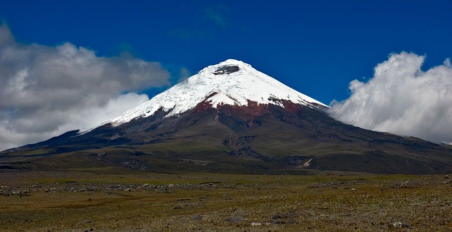
Cotopaxi's perfect cone, the green crater lake of Quilotoa and ice-capped Chimborazo — Ecuador's high Andes in five days from Quito.
Five days south from Quito along Ecuador's chain of volcanoes: Cotopaxi's glaciated cone, the 3 km-wide caldera and lake of Quilotoa, and Chimborazo, whose summit is the farthest point on Earth from the planet's centre.
- Length 5 days
- Stops 3 wonders
- Budget $350–1,100 pp
- Region Ecuadorian Andes, Ecuador
Trip map
The route
Stops in travel order — tap any one for the full wonder guide.
-
Cotopaxi 1 night
Cotopaxi Province, Ecuador
One of the highest active volcanoes in the world, its glaciated cone rising above the páramo.
-
Quilotoa 1 night
Cotopaxi Province, Ecuadorian Andes
A green crater lake inside a 3 km caldera — walk down to the shore or around the rim.
-
Chimborazo 2 nights
Chimborazo Province, Ecuador, near Riobamba
Ecuador's highest peak; drive to the Carrel refuge at 4,850 m and walk higher.
Day by day
-
Quito to Cotopaxi
Base Near Cotopaxi National Park
- Quito south toward Cotopaxi National Park
Drive into the park for views of the cone and a walk on the high páramo. Take it easy — you are already well above 3,000 m.
-
Quilotoa
Base Quilotoa village (on the rim)
- Cotopaxi area to Latacunga, then west via Zumbahua to Quilotoa
Walk down to the lake in the afternoon or circle part of the rim. Stay overnight to see the crater early, before the fog.
-
South to Chimborazo
Base Riobamba
- Quilotoa back to the Pan-American Highway and south to Riobamba
A travel day through Andean farmland, with Chimborazo looming as you approach Riobamba.
-
Chimborazo
Base Riobamba
- Riobamba to the Carrel refuge by road
Drive up to about 4,850 m, walk to the Whymper refuge at about 5,000 m if you feel well, and look for vicuñas on the way down.
-
Return to Quito
Base Quito
- Riobamba back to Quito by road (about 150 km)
Return north along the Avenue of the Volcanoes.
What it costs
Indicative per person, two sharing, 4 nights, buses and hostels at the low end, private driver and lodges at the high end. Excludes flights to Quito.
| Category | Range (per person) |
|---|---|
| TransportBuses at the low end; a private driver or rental car split two ways at the high end. | $60–450 |
| LodgingHostels to comfortable haciendas near the volcanoes. | $120–400 |
| FoodSet lunches (almuerzos) are cheap; lodges cost more. | $100–200 |
| Fees & guidesSmall community or park fees; a guide for Chimborazo or Cotopaxi at the high end. | $20–150 |
| Estimated total | $300–1,200 |
What moves the number
- Bus versus private driver
- Whether you hire mountain guides
- Lodging standard
Indicative ranges, October 2026; Ecuador uses the US dollar. Ecuador's currency is the US dollar. These are honest ranges, not quotes — real prices swing with season, group size, and how you travel. Always confirm current fares, room rates, permits, and fees with operators before you commit.
Best season & getting around
🗓️ Best time to go
December–January and June–September for the clearest mountain views; mornings are generally clearer than afternoons year-round.
🧭 Getting around
A rental car or private driver gives the most flexibility; buses link Quito, Latacunga and Riobamba, with local buses to Quilotoa.
Know before you go
- Altitude is the main risk: Quito is about 2,850 m and this route goes above 4,800 m. Ascend gradually and drink plenty of water.
- Weather changes quickly; carry warm, windproof layers even on sunny days.
- Summit climbs on Cotopaxi or Chimborazo need a certified guide and glacier equipment.
- All distances, times and prices are approximate.
South of Quito, the Pan-American Highway runs down a valley lined on both sides by volcanoes, a route known as the Avenue of the Volcanoes. This five-day trip follows it to three of the greatest: Cotopaxi’s near-perfect glaciated cone, the green crater lake of Quilotoa, and Chimborazo, Ecuador’s highest peak and the closest point on land to the stars.
Everything here happens at altitude, so the pace is deliberately gentle. Start early each day for the clearest views, carry warm layers, and let your body adjust before going above 4,000 m.
Ecuador: Avenue of the Volcanoes: common questions
How many days is the Ecuador: Avenue of the Volcanoes?
5 days — the plan is built around 4 nights. Roughly 350–450 km from Quito to Riobamba and back
When is the best time to do the Ecuador: Avenue of the Volcanoes?
December–January and June–September for the clearest mountain views; mornings are generally clearer than afternoons year-round.
How much does the Ecuador: Avenue of the Volcanoes cost?
A rough guide is $350–1,100 per person (Indicative per person, two sharing, 4 nights, buses and hostels at the low end, private driver and lodges at the high end. Excludes flights to Quito.). Indicative ranges, October 2026; Ecuador uses the US dollar. Main cost variables: Bus versus private driver; Whether you hire mountain guides; Lodging standard.
How do you get around on the Ecuador: Avenue of the Volcanoes?
A rental car or private driver gives the most flexibility; buses link Quito, Latacunga and Riobamba, with local buses to Quilotoa.
Which natural wonders does the Ecuador: Avenue of the Volcanoes include?
Cotopaxi, Quilotoa, Chimborazo.
Added